Latitude: 51.3912 / 51°23'28"N
Longitude: 1.3875 / 1°23'14"E
OS Eastings: 635764
OS Northings: 171238
OS Grid: TR357712
Mapcode National: GBR WZS.PLB
Mapcode Global: VHMCP.09BC
Plus Code: 9F3399RP+FX
Entry Name: 47 and 48, Trinity Square
Listing Date: 22 February 1973
Grade: II
Source: Historic England
Source ID: 1351052
English Heritage Legacy ID: 356696
ID on this website: 101351052
Location: Margate, Thanet, Kent, CT9
County: Kent
District: Thanet
Electoral Ward/Division: Margate Central
Parish: Non Civil Parish
Built-Up Area: Margate
Traditional County: Kent
Lieutenancy Area (Ceremonial County): Kent
Tagged with: Building
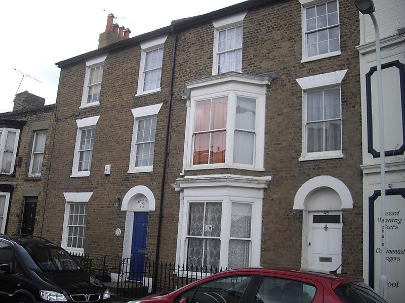
TRINITY SQUARE
1.
1380
(East Side)
Nos 47 and 48
TR 3571 SE 3/322
II GV
2.
Early C19. 3 storeys and basements brown brick. 4 sashes with most glazing
bars intact. No 48 has a 3 light canted bay through 2 storeys. Simple
round-headed doorcases with 6 fielded panelled doors. Spear railings to area.
Nos 47 to 49 (consec) form a group
Listing NGR: TR3576471237
External links are from the relevant listing authority and, where applicable, Wikidata. Wikidata IDs may be related buildings as well as this specific building. If you want to add or update a link, you will need to do so by editing the Wikidata entry.


Other nearby listed buildings