Latitude: 50.8705 / 50°52'13"N
Longitude: -1.3998 / 1°23'59"W
OS Eastings: 442330
OS Northings: 108055
OS Grid: SU423080
Mapcode National: GBR 888.6YD
Mapcode Global: FRA 76YS.Y6Z
Plus Code: 9C2WVJC2+53
Entry Name: The Drummond Arms
Listing Date: 16 September 1977
Grade: II
Source: Historic England
Source ID: 1351214
English Heritage Legacy ID: 143392
Also known as: The Drummond Arms, Southampton
Drummond Arms
ID on this website: 101351214
Location: Hythe, New Forest, Hampshire, SO45
County: Hampshire
District: New Forest
Civil Parish: Hythe and Dibden
Built-Up Area: Hythe
Traditional County: Hampshire
Lieutenancy Area (Ceremonial County): Hampshire
Church of England Parish: Hythe St John the Baptist
Church of England Diocese: Winchester
Tagged with: Pub
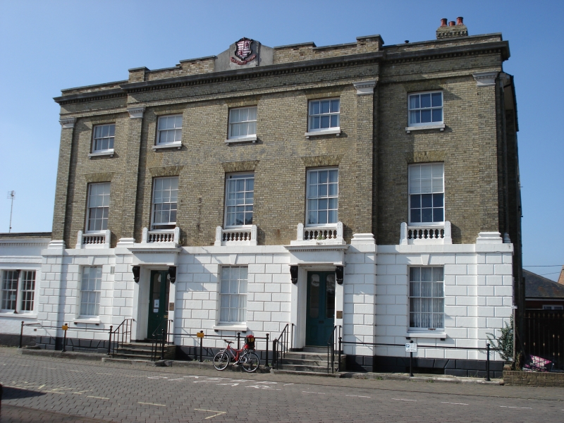
DIBDEN PROSPECT PLACE, HYTHE
SU 40 NW
9/7 The Drummond Arms
16.9.77
GV II
Hotel. Mid C19. Rusticated stone ground-floor with precise grooved
jointing, including keys to flat arches, stone first floor band supporting
the Order, upper walls of yellow brickwork in Flemish bond, pilasters with
moulded stone caps and bases, supporting a brick entablature with a stone
cornice above brick dentils, blocking course stepped in the middle part
with a central stone gable (containing a shield), rubbed flat arches, stone
cills on brackets and balusters below the 1st floor openings. Low-pitched
hipped slate roof. Classical design, with a symmetrical north-east front
elevation of three storeys, 1.3.1 windows. There are pilasters marking the
projecting of the centrepiece, at each side, and returned at each corner.
Sashes in reveals. Stone doorways at the 2nd and 4th bays, with cornice
and frieze on console brackets, above a flight of three stone steps flanked
by plain iron walls. In front of the building a moulded stone curb
supports cast-iron columns, linked by plain rails, curved inwards at each
side. The rear of the building has later extensions and on the east side
is a single-storeyed wing (of later date but continuous style), which
extends along the side of Pylewell Road as plain blocks (of former
stables).
Listing NGR: SU4232208098
External links are from the relevant listing authority and, where applicable, Wikidata. Wikidata IDs may be related buildings as well as this specific building. If you want to add or update a link, you will need to do so by editing the Wikidata entry.


Other nearby listed buildings