Approximate Location Map
Large Map »
Latitude: 52.6432 / 52°38'35"N
Longitude: -2.4522 / 2°27'7"W
OS Eastings: 369498
OS Northings: 305151
OS Grid: SJ694051
Mapcode National: GBR BX.6K0Y
Mapcode Global: WH9D9.9TJH
Plus Code: 9C4VJGVX+74
Entry Name: Sundial Immediately West of Madeley Court
Listing Date: 8 April 1983
Grade: II*
Source: Historic England
Source ID: 1352027
English Heritage Legacy ID: 362348
ID on this website: 101352027
Location: Tweedale, Telford and Wrekin, Shropshire, TF7
County: Telford and Wrekin
Civil Parish: Madeley
Traditional County: Shropshire
Lieutenancy Area (Ceremonial County): Shropshire
Church of England Parish: Madeley
Church of England Diocese: Hereford
Tagged with: Sundial
MADELEY MADELEY COURT LANE
1.
5362 Sundial immediately west
of Madeley Court
SJ 60NE 31/495
II* GV
2.
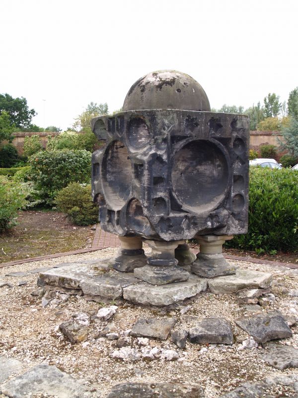
C17 astronomical sundial surmounted on squat moulded columns on base.
Large stone cuboid block about 4 ft square, with domed top and hemispherical
recessed sides with other small triangular, rectangular and various shaped recesses
for dials.
Listing NGR: SJ6949805151
External links are from the relevant listing authority and, where applicable, Wikidata. Wikidata IDs may be related buildings as well as this specific building. If you want to add or update a link, you will need to do so by editing the Wikidata entry.


Other nearby listed buildings
