Latitude: 50.9167 / 50°55'0"N
Longitude: 0.4843 / 0°29'3"E
OS Eastings: 574721
OS Northings: 115966
OS Grid: TQ747159
Mapcode National: GBR PWF.H81
Mapcode Global: FRA C6XP.6HM
Plus Code: 9F22WF8M+MP
Entry Name: 24, High Street
Listing Date: 13 May 1987
Grade: II
Source: Historic England
Source ID: 1352864
English Heritage Legacy ID: 292144
ID on this website: 101352864
Location: Battle, Rother, East Sussex, TN33
County: East Sussex
District: Rother
Civil Parish: Battle
Built-Up Area: Battle
Traditional County: Sussex
Lieutenancy Area (Ceremonial County): East Sussex
Church of England Parish: Battle St Mary the Virgin
Church of England Diocese: Chichester
Tagged with: Building
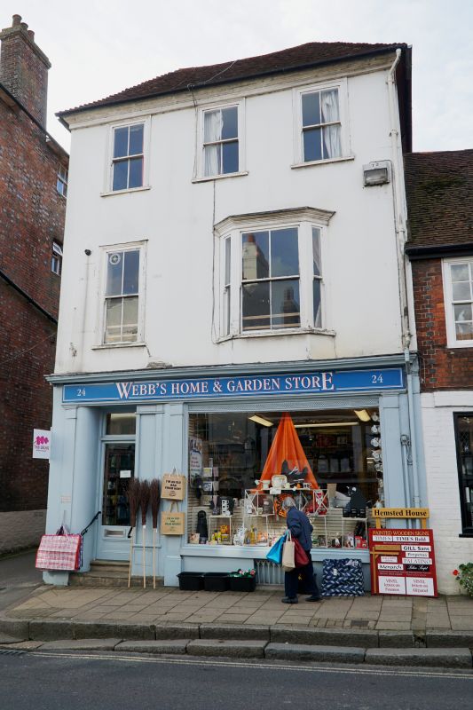
TQ 7415-7515 BATTLE HIGH STREET
(south west side)
41/21 No 24
GV II
Early to mid C19. Three storeys. Three windows. Stuccoed. Eaves cornice.
Hipped tiled roof. Glazing bars missing. One bay window on first floor. C19
shop front.
Listing NGR: TQ7471815966
External links are from the relevant listing authority and, where applicable, Wikidata. Wikidata IDs may be related buildings as well as this specific building. If you want to add or update a link, you will need to do so by editing the Wikidata entry.


Other nearby listed buildings