Latitude: 51.0622 / 51°3'43"N
Longitude: -0.3296 / 0°19'46"W
OS Eastings: 517150
OS Northings: 130536
OS Grid: TQ171305
Mapcode National: GBR HJN.7J4
Mapcode Global: FRA B669.TNX
Plus Code: 9C3X3M6C+V5
Entry Name: 1-7, Blackhorse Way
Listing Date: 20 May 1949
Last Amended: 26 July 1974
Grade: II
Source: Historic England
Source ID: 1353922
English Heritage Legacy ID: 298091
ID on this website: 101353922
Location: Horsham, West Sussex, RH12
County: West Sussex
District: Horsham
Electoral Ward/Division: Denne
Parish: Horsham
Built-Up Area: Horsham
Traditional County: Sussex
Lieutenancy Area (Ceremonial County): West Sussex
Church of England Parish: Horsham St Mary the Virgin
Church of England Diocese: Chichester
Tagged with: Building
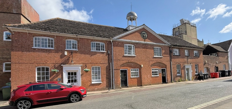
BLACKHORSE WAY 1. 1236 (North Side) Nos 1 to 7 (odd) (formerly listed as stables to North and North-West of Manor House) TQ 1730 1/18B 20.5.49. II GV 2. Nos 1, 3 & 5, 2 storeys. 8 windows. Red brick. Moulded wooden eaves cornice. Hipped roof of Horsham slabs. The centre portion, with 2 windows on 1st floor and 2 coach-house below, projects slightly with pediment over having a clock in tympanum and a cupola on the roof above. Windows with segmental heads, those on the 1st floor of east wing enlarged. Doorway with pilasters and projecting cornice in centre of each wing. No 7 to the west of the former stables in Blackhorse Way is a block which was formerly the groom's quarters and, until recently, linked to the stables by a curved flanking wall. 2 storeys, 6 windows. Red brick and grey headers. Horsham slab roof. Windows with segmental heads. Sashes, glazing bars missing. Nos 1 to 7 (odd) form a group with all the listed buildings in South Street and with The Manor House. Stables to the south and Nos 24 to 3l (consec), Causeway.
Listing NGR: TQ1712230540
External links are from the relevant listing authority and, where applicable, Wikidata. Wikidata IDs may be related buildings as well as this specific building. If you want to add or update a link, you will need to do so by editing the Wikidata entry.


Other nearby listed buildings