Approximate Location Map
Large Map »
Latitude: 54.9724 / 54°58'20"N
Longitude: -1.6153 / 1°36'55"W
OS Eastings: 424721
OS Northings: 564263
OS Grid: NZ247642
Mapcode National: GBR SP0.CW
Mapcode Global: WHC3R.581Y
Plus Code: 9C6WX9CM+XV
Entry Name: South Front of Grainger Market
Listing Date: 14 June 1954
Grade: I
Source: Historic England
Source ID: 1355260
English Heritage Legacy ID: 304761
ID on this website: 101355260
Location: Newcastle Helix, Newcastle upon Tyne, Tyne and Wear, NE1
County: Newcastle upon Tyne
Electoral Ward/Division: Westgate
Parish: Non Civil Parish
Built-Up Area: Newcastle upon Tyne
Traditional County: Northumberland
Lieutenancy Area (Ceremonial County): Tyne and Wear
Church of England Parish: Newcastle St Andrew
Church of England Diocese: Newcastle
Tagged with: Architectural structure
NZ 2464 SE NEWCASTLE UPON TYNE NUN STREET
(north side)
20/432
14/6/54. Nos. 1 to 25 odd
(south front of
Grainger Market)
G.V. I
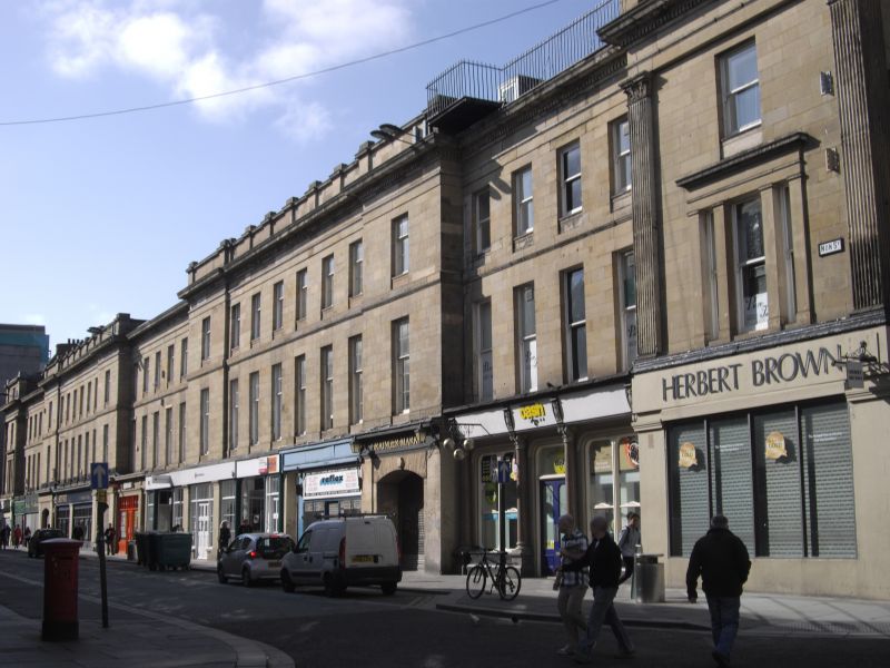
End bays are returns of Nos. 11-43 Clayton Street (q.v.) and Nos. 95-137 Grainger
Street (q.v.)and are described here since they complete the composition. Shops
and public house, forming south elevation of covered market. 1835 by John Dobson
for Richard Grainger. Sandstone ashlar; roof not visible. Classical style. 3
storeys; 34 bays in all. 5 entrances to market, 2 at right with segmental arches
and pilasters. Ground floor shops C20. Giant Corinthian pilasters to end pavilions.
Sash windows, most with glazing bars, in plain reveals; second-floor windows have
aprons and slightly-projecting sills; some renewed first-floor lintels. End bays
have tripartite window in architraves on floor band; second-floor dentilled cornice.
Top parapet with pilasters to 8-bay projections. Blocking course to intermediate
bays.
Listing NGR: NZ2472164263
External links are from the relevant listing authority and, where applicable, Wikidata. Wikidata IDs may be related buildings as well as this specific building. If you want to add or update a link, you will need to do so by editing the Wikidata entry.


Other nearby listed buildings
