Approximate Location Map
Large Map »
Latitude: 51.6423 / 51°38'32"N
Longitude: -1.8558 / 1°51'20"W
OS Eastings: 410073
OS Northings: 193726
OS Grid: SU100937
Mapcode National: GBR 3RV.ZKZ
Mapcode Global: VHB2Z.SZ8F
Plus Code: 9C3WJ4RV+VM
Entry Name: 46, High Street
Listing Date: 17 January 1955
Grade: II
Source: Historic England
Source ID: 1356063
English Heritage Legacy ID: 317787
ID on this website: 101356063
Location: Cricklade, Wiltshire, SN6
County: Wiltshire
Civil Parish: Cricklade
Built-Up Area: Cricklade
Traditional County: Wiltshire
Lieutenancy Area (Ceremonial County): Wiltshire
Church of England Parish: Cricklade
Church of England Diocese: Bristol
Tagged with: Building
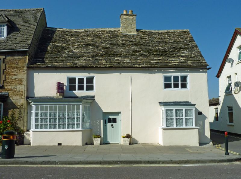
46 High Street is a former hall house, dating from the C15 or early C16.
MATERIALS: The house is clad in rubble stone, rendered and painted, under a Cotswold stone tile roof with a stone rubble stack. The gable end has been rebuilt above the eaves line in modern brick. At least the first floor, and possibly the entire building, is framed in timber behind the stone rubble cladding, partly visible in the interior.
PLAN: The house is L-shaped on plan, with the original main range, formerly a cross-passage house, facing the road; a later extension, which replaces a longer and more substantial cross wing, runs westwards from the rear.
EXTERIOR: The main range is of two storeys and three bays with a roughly central entrance doorway; this houses a wide C18 door with two small glazed panels. There are two C19 three-light timber casement windows to the first floor. To the south, the ground floor has a canted bay, with multi-paned fixed windows. To the north, there is a smaller, rectangular bay with timber casement windows. To the rear, there are the truncated remains of a two-storey gabled cross wing at the north end; a single storey lean-to extension which replaced it in the early C20 remains in situ. A further lean-to extension, probably dating from the C19, runs across the rear of the main range. All the windows in the rear are uPVC replacements, that to the first floor of the main range in an enlarged opening.
INTERIOR: The interior has a single room either side of the cross passage. The room to the south, formerly the service room, has an exposed chamfered and stepped stopped ceiling beam and plain wall plate to the south wall. To the north, formerly the open hall, the ground floor room has a ceiling inserted in the C17; this has an exposed beam and ceiling joists with chamfers and stepped runout stops, and a large fireplace with segmental arched beam, set in a massive stone stack which rises through the house. A winder stair, probably inserted at the same time as the ceiling and the stack, is set in the alcove to the east of the chimney stack. The first floor room to the south, formerly the solar, has some exposed timber framing. Above the former cross passage, which must therefore have been open to the roof, is a two-light timber window with trefoil heads. The roof trusses spring from the exposed wall posts in the first floor. The attic retains the original roof structure largely unaltered: two mid-trusses, end trusses, single threaded purlins and a diagonally set ridge-purlin. The more northerly mid-truss is an open truss, with a chamfered collar and arch braces; the remaining trusses, one to the south of the passage and the others in the walls, all have cambered collars and tie beams, and there is evidence of windbraces in the form of mortices, though most have been lost apart from one at the rear of the stack. In the gable end is a small two-light timber window with ogee mullions. The timbers in the northern and central bays have obvious smoke-blackening dating from the period when the hall of the house was open to the roof.
SUBSIDIARY FEATURES: There are stone boundary markers at the side and rear of the plot, which apparently accord with the layout of the original Saxon burgage plot.
HISTORY: The High Street is one of the streets remaining in the original layout of the Saxon town, which was laid out with long, narrow burgage plots to either side of the wide central street; 46 High Street apparently retains the full length of its original plot to the rear of the house. 46 High Street appears from stylistic evidence to have been built in the C15 or C16, as a three-bay hall house range facing the street. A substantial, two-storey rear wing was added to the north, perhaps for a kitchen, probably in the C17, and some internal alterations took place apparently at the same time. By 1837, when the tithe map for the town was drawn up, the house consisted of these two ranges. In the later C19, alterations to the front of the building took place, with the addition of bay windows to the ground floor. The rear range was removed in the earlier C20, and replaced with a single-storey lean-to extension at the same time; and a lean-to extension along the width of the rear of the house between this new extension and the neighbouring property was added in the later C19. The house has apparently remained in use as a single dwelling throughout its life, though the bays to the front may have been used as shop windows.
SOURCES: Stanley Jones and T J Smith, 'A medieval timber-framed house in Cricklade', Wiltshire Archaeological and Natural History Magazine, Vol. 55(1954), 344-352
REASONS FOR DESIGNATION DECISION:
46 High Street, Cricklade is designated at Grade II for the following principal reasons:
* A C15 or early C16 former hall house which retains its largely complete first floor timber frame
* The original plan form, as a cross-passage house, is unaltered apart from the addition of lean-to extensions to the rear
* The roof timbers include an impressive chamfered mid-truss with arch braces, and smoke-blackened timbers to the north end, formerly the open hall
Listing NGR: SU1006993728
External links are from the relevant listing authority and, where applicable, Wikidata. Wikidata IDs may be related buildings as well as this specific building. If you want to add or update a link, you will need to do so by editing the Wikidata entry.


Other nearby listed buildings
