Latitude: 53.4328 / 53°25'57"N
Longitude: -2.9623 / 2°57'44"W
OS Eastings: 336166
OS Northings: 393316
OS Grid: SJ361933
Mapcode National: GBR 79C.6F
Mapcode Global: WH871.GZM8
Plus Code: 9C5VC2MQ+33
Entry Name: 39 and 41, Anfield Road
Listing Date: 14 March 1975
Last Amended: 19 June 1985
Grade: II
Source: Historic England
Source ID: 1356297
English Heritage Legacy ID: 213696
ID on this website: 101356297
Location: Anfield, Liverpool, Merseyside, L4
County: Liverpool
Electoral Ward/Division: Anfield
Parish: Non Civil Parish
Built-Up Area: Liverpool
Traditional County: Lancashire
Lieutenancy Area (Ceremonial County): Merseyside
Church of England Parish: Walton Breck Christ Church and Holy Trinity
Church of England Diocese: Liverpool
Tagged with: Building
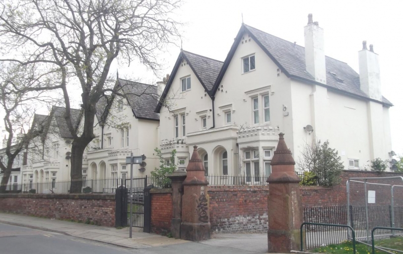
SJ 39 SE ANFIELD ROAD
L4
4/94 Nos. 39 & 41
(formerly
listed with
14.3.75 Nos. 35,37,43
and 45)
G.V. II
Pair of semi-detached houses. Mid C19 Stucco with slate
roof. 2 storeys with attics, 2 bays to each house and 2
gables. Ground floor has canted bay windows with hollow-
chamfered cross windows and embattled cresting which flank
projecting paired 4-centred entrances, now windows. All
windows have C20 casements. 1st floor has 2:1:1:2- light
windows with hollow-chamfered openings and label moulds.
Plain square attic windows. Rear elevation similar, with
quoins.
Listing NGR: SJ3616693316
External links are from the relevant listing authority and, where applicable, Wikidata. Wikidata IDs may be related buildings as well as this specific building. If you want to add or update a link, you will need to do so by editing the Wikidata entry.


Other nearby listed buildings