Approximate Location Map
Large Map »
Latitude: 51.109 / 51°6'32"N
Longitude: 0.5635 / 0°33'48"E
OS Eastings: 579546
OS Northings: 137536
OS Grid: TQ795375
Mapcode National: GBR PT6.K7R
Mapcode Global: VHJN6.QD86
Plus Code: 9F324H57+H9
Entry Name: Church of the Holy Trinity
Listing Date: 19 May 1986
Grade: II
Source: Historic England
Source ID: 1356540
English Heritage Legacy ID: 169095
ID on this website: 101356540
Location: Trinity Church, Sissinghurst, Tunbridge Wells, Kent, TN17
County: Kent
District: Tunbridge Wells
Civil Parish: Cranbrook & Sissinghurst
Built-Up Area: Sissinghurst
Traditional County: Kent
Lieutenancy Area (Ceremonial County): Kent
Tagged with: Church building
CRANBROOK THE STREET, (NORTH
TQ 7837-7937 SIDE), SISSINGHURST
8/244
- Church of the Holy
GV Trinity
II
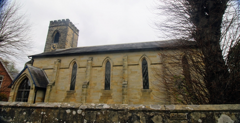
Anglican church. 1837-38 by J Jennings of Hawkhurst. Sandstone with parapet
to plain tiled roof. West tower, nave and shallow chancel. West tower of
2 stages with belfry. openings. Six-bay nave with lancet windows. Triple east
window with hood mould on demi-angels. Listed for group value.
Listing NGR: TQ7954637536
External links are from the relevant listing authority and, where applicable, Wikidata. Wikidata IDs may be related buildings as well as this specific building. If you want to add or update a link, you will need to do so by editing the Wikidata entry.


Other nearby listed buildings
