Latitude: 53.578 / 53°34'40"N
Longitude: -2.2961 / 2°17'45"W
OS Eastings: 380494
OS Northings: 409086
OS Grid: SD804090
Mapcode National: GBR DWD2.Q3
Mapcode Global: WH97X.PBVC
Plus Code: 9C5VHPH3+6H
Entry Name: Heaton Grove
Listing Date: 13 February 1978
Grade: II
Source: Historic England
Source ID: 1356844
English Heritage Legacy ID: 210674
ID on this website: 101356844
Location: Fletcher Fold, Bury, Greater Manchester, BL9
County: Bury
Electoral Ward/Division: Redvales
Parish: Non Civil Parish
Built-Up Area: Bury
Traditional County: Lancashire
Lieutenancy Area (Ceremonial County): Greater Manchester
Church of England Parish: Bury, Roch Valley
Church of England Diocese: Manchester
Tagged with: Architectural structure
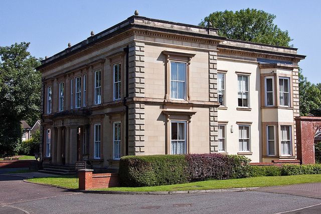
SD 80 NW MANCHESTER ROAD (east side)
8/44
13.02.78
Heaton Grove
II
Circa 1840. For Thomas Heaton (workhouse governor at Redvales 1820). Classical
in style. Ashlar. Symmetrical. Two storeys of equal height and five large sash windows
in moulded architraves with bracketed cornices and sills, the central one having
a half-width one each side. Wide Doric porch of two pillars, two columns and entablature.
Quoins, plinth, first floor sill-band, cornice and parapet surmounted by four vases.
Sides similar. Two and three-storey extension of c 1870 to rear, of red brick with
scored rendering and stone dressings. Conical roof rises above staircase tower.
Listing NGR: SD8049409086
External links are from the relevant listing authority and, where applicable, Wikidata. Wikidata IDs may be related buildings as well as this specific building. If you want to add or update a link, you will need to do so by editing the Wikidata entry.


Other nearby listed buildings