Latitude: 51.4966 / 51°29'47"N
Longitude: -0.2521 / 0°15'7"W
OS Eastings: 521432
OS Northings: 178963
OS Grid: TQ214789
Mapcode National: GBR 9M.F3H
Mapcode Global: VHGQX.LN32
Plus Code: 9C3XFPWX+J5
Entry Name: 9 and 11 Bath Road
Listing Date: 2 February 1970
Grade: II
Source: Historic England
Source ID: 1358671
English Heritage Legacy ID: 202399
ID on this website: 101358671
Location: Bedford Park, Hounslow, London, W4
County: London
District: Hounslow
Electoral Ward/Division: Chiswick Homefields
Parish: Non Civil Parish
Built-Up Area: Hounslow
Traditional County: Middlesex
Lieutenancy Area (Ceremonial County): Greater London
Church of England Parish: St Michael and All Angels Bedford Park
Church of England Diocese: London
Tagged with: Building
TQ 2178 NW
7/70
2.2.70.
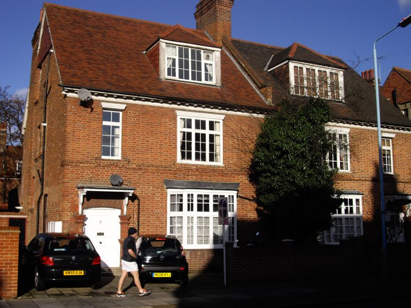
BATH ROAD W4 (Bedford Park)
Nos 9 and 11
GII
A pair with modillion eaves cornice.Single-storeyed bays;flat door hoods.No 9 has piers to front garden.
Listing NGR: TQ2143278963
External links are from the relevant listing authority and, where applicable, Wikidata. Wikidata IDs may be related buildings as well as this specific building. If you want to add or update a link, you will need to do so by editing the Wikidata entry.


Other nearby listed buildings