Approximate Location Map
Large Map »
Latitude: 51.4082 / 51°24'29"N
Longitude: 0.1597 / 0°9'34"E
OS Eastings: 550303
OS Northings: 169903
OS Grid: TQ503699
Mapcode National: GBR S2.2XR
Mapcode Global: VHHNZ.QV8T
Plus Code: 9F32C555+7V
Entry Name: Coal Duty Boundary Marker
Listing Date: 21 April 1986
Grade: II
Source: Historic England
Source ID: 1359402
English Heritage Legacy ID: 198736
ID on this website: 101359402
Location: Stonehill Green, Sevenoaks, Kent, DA2
County: Kent
District: Sevenoaks
Civil Parish: Swanley
Built-Up Area: Swanley
Traditional County: Kent
Lieutenancy Area (Ceremonial County): Kent
Church of England Parish: North Cray St James
Church of England Diocese: Rochester
Tagged with: Coal-tax post Coal duty marker
5005
TQ 56 NW 4/105
BIRCHWOOD ROAD
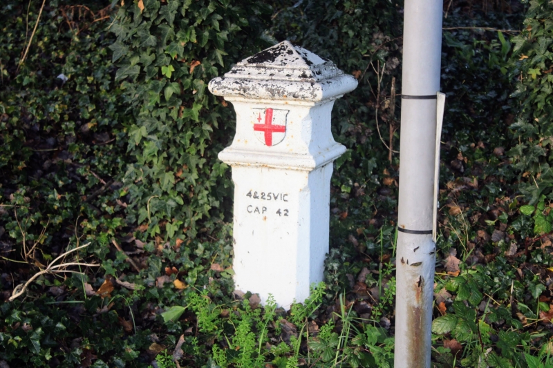
Coal duty boundary marker
GII
Coal duty boundary marker,Erected in 1861 or soon after.Cast by Henry Grissell at the Regent Canal Ironworks.Cast iron.Square post with chamfered edges,projecting cornice and frieze bearing armorial shield.Post set up under the London Coal and Wine Duties(Continuance)Act of 1861.
Listing NGR: TQ5030369903
External links are from the relevant listing authority and, where applicable, Wikidata. Wikidata IDs may be related buildings as well as this specific building. If you want to add or update a link, you will need to do so by editing the Wikidata entry.


Other nearby listed buildings
