Approximate Location Map
Large Map »
Latitude: 53.42 / 53°25'12"N
Longitude: -3.0003 / 3°0'0"W
OS Eastings: 333621
OS Northings: 391936
OS Grid: SJ336919
Mapcode National: GBR 71J.00
Mapcode Global: WH876.W9HG
Plus Code: 9C5RCXCX+2V
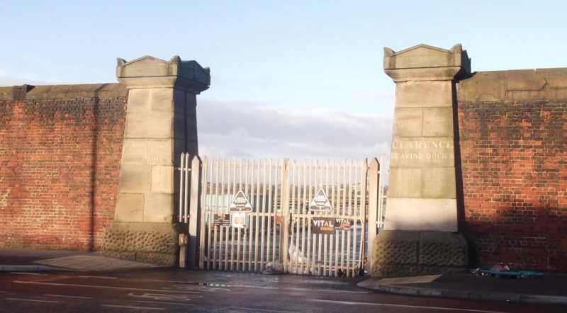
Entry Name: Gate to Clarence and Clarence Graving Docks
Listing Date: 19 June 1985
Grade: II
Source: Historic England
Source ID: 1360218
English Heritage Legacy ID: 359712
ID on this website: 101360218
Location: Vauxhall, Liverpool, Merseyside, L3
County: Liverpool
Electoral Ward/Division: Kirkdale
Parish: Non Civil Parish
Built-Up Area: Liverpool
Traditional County: Lancashire
Lieutenancy Area (Ceremonial County): Merseyside
Church of England Parish: Liverpool Our Lady and St Nicholas
Church of England Diocese: Liverpool
Tagged with: Gate
SJ 39 SW WATERLOO ROAD
L3
3/1330 Gate to Clarence
and Clarence
- Graving Docks
G.V. II
Gate piers, gates removed. 1830's. J. Hartley. Square
battered stone piers with rusticated bases and gabled caps
with acroteria; C20 gates.
Listing NGR: SJ3362191936
External links are from the relevant listing authority and, where applicable, Wikidata. Wikidata IDs may be related buildings as well as this specific building. If you want to add or update a link, you will need to do so by editing the Wikidata entry.


Other nearby listed buildings
