Latitude: 52.5728 / 52°34'21"N
Longitude: -1.2047 / 1°12'16"W
OS Eastings: 453995
OS Northings: 297512
OS Grid: SP539975
Mapcode National: GBR 8N4.N88
Mapcode Global: WHDJP.GLKJ
Plus Code: 9C4WHQFW+44
Entry Name: All Saints Church Rooms
Listing Date: 23 February 1987
Grade: II
Source: Historic England
Source ID: 1361063
English Heritage Legacy ID: 188983
ID on this website: 101361063
Location: Narborough, Blaby, Leicestershire, LE19
County: Leicestershire
District: Blaby
Civil Parish: Narborough
Built-Up Area: Narborough/Enderby
Traditional County: Leicestershire
Lieutenancy Area (Ceremonial County): Leicestershire
Church of England Parish: Narborough All Saints
Church of England Diocese: Leicester
Tagged with: Architectural structure
NARBOROUGH SCHOOL LANE SP 59 NW 7/61 All Saints' Church Rooms GV II
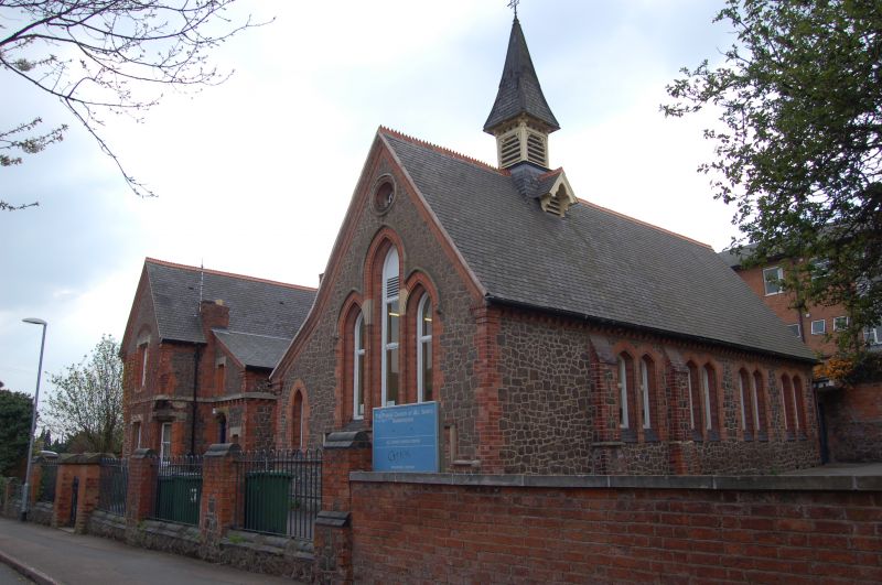
Former church school with house for school-mistress, now church rooms. 1873. Granite rubble with red brick and limestone dressings; tarred slate roof with zig-zag tile right; brick chimneys. U-plan, with house for school-mistress projecting to left, schoolroom projecting to right, and lobbies in inner angles. Both projecting wings are gabled. Chamfered plinth, moulded brick eaves and gable verges. School, to right, is in early English style with moulded sill string and arched windows in moulded brick surrounds. Below each main window is a terracotta frieze with scroll ornament. Centre bay has pair of arched lights with cusped roundel above, cusped hoodmould and gable over. Projecting right bay has triple lancets with dripmould, and round window above. Left side of this wing has lean-to lobby with lancet to front, and gable over moulded arch with hoodmould and double doors in left side, All hoodmoulds have carved stops. Right side of wing has 4 pairs of lancets and 2 buttresses. To centre of ridge of school wing is a square bell turret with louvred wooden bellcote, slender spirelet, and cusped gables over side louvres on base. House to left is simpler in style and is of 2 storeys with Limestone band course at first floor level. Projecting gable has sash windows with chamfered brick jambs, and limestone sills and lintels. Upper window also has brick relieving arch. Ground floor has canted corners with narrow sashes, the upper storey quoins off-set and carried on shaped stone brackets. Right side of wing has lean-to lobby with upper storey jettied on shaped brick corbels, irregular single lights, and door with shaped stone arch over fanlight.
Listing NGR: SP5399597512
External links are from the relevant listing authority and, where applicable, Wikidata. Wikidata IDs may be related buildings as well as this specific building. If you want to add or update a link, you will need to do so by editing the Wikidata entry.


Other nearby listed buildings