Latitude: 53.8909 / 53°53'27"N
Longitude: -2.769 / 2°46'8"W
OS Eastings: 349558
OS Northings: 444132
OS Grid: SD495441
Mapcode National: GBR 9R3F.BY
Mapcode Global: WH850.FGNJ
Plus Code: 9C5VV6RJ+9C
Entry Name: Milestone
Listing Date: 9 January 1986
Grade: II
Source: Historic England
Source ID: 1361909
English Heritage Legacy ID: 185395
ID on this website: 101361909
Location: Bowgreave, Wyre, Lancashire, PR3
County: Lancashire
District: Wyre
Civil Parish: Barnacre-with-Bonds
Built-Up Area: Bowgreave
Traditional County: Lancashire
Lieutenancy Area (Ceremonial County): Lancashire
Church of England Parish: Garstang St Thomas
Church of England Diocese: Blackburn
Tagged with: Milestone
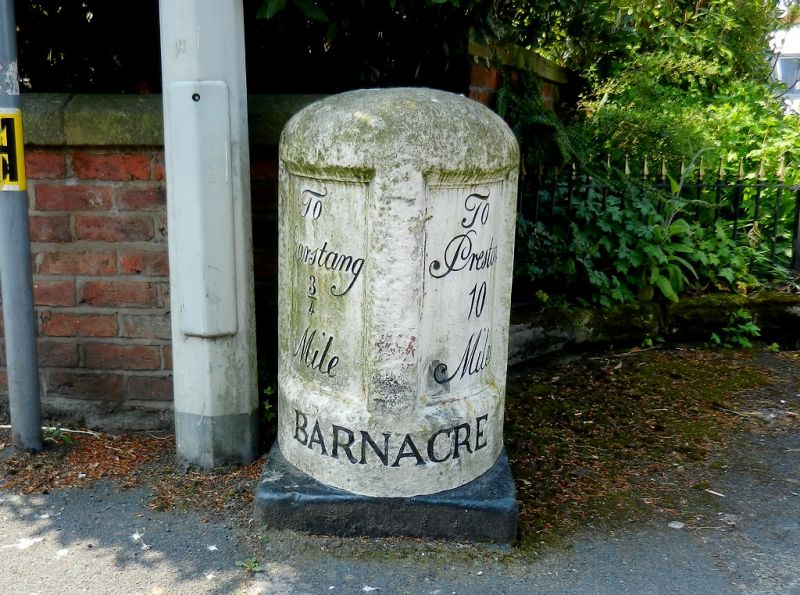
BARNACRE-WITH-BONDS B6430
SD 44 SE
7/8 Milestone
-
- II
Milestone, late C18. Painted sandstone with cast-iron plates. Half-oval on
plan with rounded top. Inscribed 'BARNACRE' around base. Above are 2 iron
panels with moulded borders. The left-hand one is inscribed: 'To Garstang
3/4 Mile'. Right-hand one inscribed: 'To Preston 10 Miles'.
Listing NGR: SD4955844132
External links are from the relevant listing authority and, where applicable, Wikidata. Wikidata IDs may be related buildings as well as this specific building. If you want to add or update a link, you will need to do so by editing the Wikidata entry.


Other nearby listed buildings