Approximate Location Map
Large Map »
Latitude: 53.6909 / 53°41'27"N
Longitude: -2.235 / 2°14'5"W
OS Eastings: 384580
OS Northings: 421626
OS Grid: SD845216
Mapcode National: GBR DTTR.YN
Mapcode Global: WHB8H.MHYC
Plus Code: 9C5VMQR8+82
Entry Name: Waterbarn Baptist Chapel
Listing Date: 30 November 1984
Grade: II
Source: Historic England
Source ID: 1361948
English Heritage Legacy ID: 185590
ID on this website: 101361948
Location: Waterbarn, Rossendale, Lancashire, OL13
County: Lancashire
District: Rossendale
Electoral Ward/Division: Stacksteads
Parish: Non Civil Parish
Built-Up Area: Bacup
Traditional County: Lancashire
Lieutenancy Area (Ceremonial County): Lancashire
Church of England Parish: Tunstead Holy Trinity with Bacup St Saviour
Church of England Diocese: Manchester
Tagged with: Chapel
SD 82 SW BACUP BRANDWOOD ROAD
Brandwood
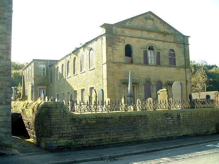
6/13 Waterbarn Baptist Chapel
-
- II
Baptist chapel, dated 1847 in gable. Sandstone ashlar facade,
otherwise coursed rubble, slate roof. Rectangular plan (school
attached at south end not included in the item). Two storeys;
symmetrical facade in simple classical style has pilastered corners,
1st floor sill band, string course, moulded cornice and pedimented
gable: at ground floor 2 doorways with panelled doors, rectangular
fanlights, cornices on brackets, and between them 2 round-headed
windows; at 1st floor a Venetian window flanked by round-headed
windows, and in the pediment of the gable a tablet lettered BAPTIST
CHAPEL
1847
protected by a cornice on brackets. Side walls have 7 windows on
each floor, rectangular at ground floor and round-headed at
1st floor, all with altered glazing. Interior: horseshoe-shaped
gallery supported on slim iron columns with palm capitals (but now
ceiled) ; segmentally-curved box pews.
Listing NGR: SD8458021626
External links are from the relevant listing authority and, where applicable, Wikidata. Wikidata IDs may be related buildings as well as this specific building. If you want to add or update a link, you will need to do so by editing the Wikidata entry.


Other nearby listed buildings
