Approximate Location Map
Large Map »
Latitude: 53.7454 / 53°44'43"N
Longitude: -2.3558 / 2°21'20"W
OS Eastings: 376631
OS Northings: 427724
OS Grid: SD766277
Mapcode National: GBR CTZ4.S4
Mapcode Global: WH973.S4C2
Plus Code: 9C5VPJWV+4M
Entry Name: Toll Bar House
Listing Date: 9 March 1984
Grade: II
Source: Historic England
Source ID: 1362016
English Heritage Legacy ID: 183819
ID on this website: 101362016
Location: Oak Hill Park, Barnfield, Hyndburn, Lancashire, BB5
County: Lancashire
District: Hyndburn
Electoral Ward/Division: Barnfield
Parish: Non Civil Parish
Built-Up Area: Accrington
Traditional County: Lancashire
Lieutenancy Area (Ceremonial County): Lancashire
Church of England Parish: Accrington Christ Church
Church of England Diocese: Blackburn
Tagged with: House
ACCRINGTON MANCHESTER ROAD
SD 72 NE
5/22 Toll Bar House
-
- II
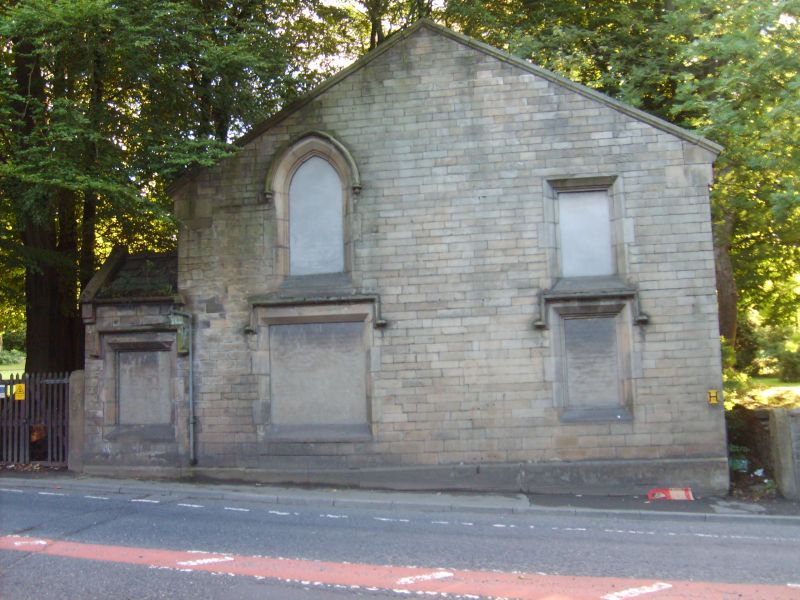
Former toll bar house, early C19. Coursed dressed sandstone, slate roof.
Rectangular plan of 4 bays, gable to road. Two storeys in Tudor style.
Gabled porch on south side at corner with road, a rectangular window in
the side to the road; gable wall has 2 rectangular ground floor windows,
(that on the left larger), at 1st floor a large arched window and a
smaller rectangular window; all these openings have chamfered and
moulded reveals. Most have prominent hood moulds, and are now blocked.
Gable copings are supported by moulded kneelers.
Listing NGR: SD7663127724
External links are from the relevant listing authority and, where applicable, Wikidata. Wikidata IDs may be related buildings as well as this specific building. If you want to add or update a link, you will need to do so by editing the Wikidata entry.


Other nearby listed buildings
