Approximate Location Map
Large Map »
Latitude: 51.2875 / 51°17'15"N
Longitude: 0.2864 / 0°17'10"E
OS Eastings: 559531
OS Northings: 156748
OS Grid: TQ595567
Mapcode National: GBR XH.QW1
Mapcode Global: VHHPM.XW8V
Plus Code: 9F3277QP+2G
Entry Name: The Town House
Listing Date: 1 August 1952
Last Amended: 3 May 1984
Grade: II
Source: Historic England
Source ID: 1362377
English Heritage Legacy ID: 357282
ID on this website: 101362377
Location: Ightham, Tonbridge and Malling, Kent, TN15
County: Kent
District: Tonbridge and Malling
Civil Parish: Ightham
Built-Up Area: Ightham
Traditional County: Kent
Lieutenancy Area (Ceremonial County): Kent
Church of England Parish: Ightham St Peter
Church of England Diocese: Rochester
Tagged with: House
TQ 5956 IGHTHAM THE STREET
5/14 (north side)
1.8.52 The Town House
(formerly listed under
Main Road)
GV
II
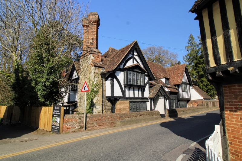
Hall-house, altered during the C16 and restored during the late C19. Central hall
with return gable wings to left and right. Timber-frame with plaster infilling,
close-studded to right, square-framed under left gable with curved braces. Some brick
infill on ground floor. Late Cl9 decorated barge-boards in gables. Plain tiled roof,
the central hall hipped. Small end stack to right, tall pair of brick stacks, square
and diagonally placed, at left end. Two gabled dormers in centre. One storey and
attic in centre, 2 storeys at ends. Projecting C19 gabled porch with decorated
barge-boards and inset linenfold panelled door to left of centre, tall pentice-roofed
oriel to right of centre. Projecting oriel with tiled pediment-gabled hood on first
floor under left-hand gable, simple metal lattic casements in wooden frames on ground
floor under left-hand gable and on both floors under right-hand gable. Interior: The
Central hall has been opened although the roof timbers are C19 with an attic above.
Listing NGR: TQ5953156748
External links are from the relevant listing authority and, where applicable, Wikidata. Wikidata IDs may be related buildings as well as this specific building. If you want to add or update a link, you will need to do so by editing the Wikidata entry.


Other nearby listed buildings
