Approximate Location Map
Large Map »
Latitude: 51.1153 / 51°6'54"N
Longitude: 0.642 / 0°38'31"E
OS Eastings: 585016
OS Northings: 138427
OS Grid: TQ850384
Mapcode National: GBR QVN.14F
Mapcode Global: VHJN8.27RC
Plus Code: 9F324J8R+4R
Entry Name: 32, High Street
Listing Date: 16 August 1962
Grade: II
Source: Historic England
Source ID: 1362893
English Heritage Legacy ID: 180163
ID on this website: 101362893
Location: Biddenden, Ashford, Kent, TN27
County: Kent
District: Ashford
Civil Parish: Biddenden
Built-Up Area: Biddenden
Traditional County: Kent
Lieutenancy Area (Ceremonial County): Kent
Tagged with: Building
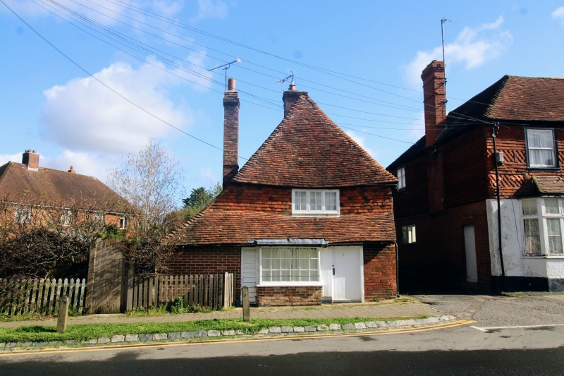
BIDDENDEN HIGH STREET
1.
5272 (north side)
No 32
TQ 8538 16/61 16.8.62.
II GV
2.
This building stands sideways to the High Street facing an alley. C17 or earlier
timber-framed building refaced on the ground floor with red brick, above with
weatherboarding except for the south front which is tile hung. Two storeys,
steeply-pitched hipped tiled roof. Three casement windows. The south front
has a small C18 shop window with its glazing bars intact.
Listing NGR: TQ8501938430
External links are from the relevant listing authority and, where applicable, Wikidata. Wikidata IDs may be related buildings as well as this specific building. If you want to add or update a link, you will need to do so by editing the Wikidata entry.


Other nearby listed buildings
