Approximate Location Map
Large Map »
Latitude: 51.2557 / 51°15'20"N
Longitude: 0.4229 / 0°25'22"E
OS Eastings: 569169
OS Northings: 153513
OS Grid: TQ691535
Mapcode National: GBR NPY.CQ1
Mapcode Global: VHJMC.8PYR
Plus Code: 9F327C4F+75
Entry Name: The Coach House the Wool Shop
Listing Date: 23 October 1987
Grade: II
Source: Historic England
Source ID: 1363047
English Heritage Legacy ID: 178994
ID on this website: 101363047
Location: Wateringbury, Tonbridge and Malling, Kent, ME18
County: Kent
District: Tonbridge and Malling
Civil Parish: Wateringbury
Built-Up Area: Wateringbury
Traditional County: Kent
Lieutenancy Area (Ceremonial County): Kent
Church of England Parish: Wateringbury St John the Baptist
Church of England Diocese: Rochester
Tagged with: Architectural structure
(2)
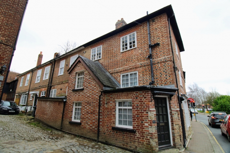
TQ 65 SE TONBRIDGE ROAD
2/138 No 194, The Wool Shop
II and The Coach House
2 Houses and shop. c1830, the Coach House altered in C20. Built of red
brick with mainly vitrified heads on ragstone base with ragstone galleting.
Hipped slate roof with 1 tall brick chimney stack. 2 to 3 storeys, 1
window to front, 8 as to side. Front has 2nd floor window with C20 metal
casement. 1st floor window is a C19 3 light window. Ground floor has
plain shop front and half-glazed door with brackets. To left is an extended
opening with modern window. Side elevation has 8 windows, mainly sashes
in moulded architraves with rubbed brick voussoirs but 2 top floor right
side ones replaced with shorter late C19 casements. Plat band. Ground
floor of the Coach House has left side garage door, modern 4 light bay
and modern Georgian style doorcase with round-headed fanlight and 6 fielded
panelled door. To right of this is an early C19 plank door with divided
rectangular fanlight. Rest of windows are later casements. C20 extension
on ground floor.
Listing NGR: TQ6916953512
External links are from the relevant listing authority and, where applicable, Wikidata. Wikidata IDs may be related buildings as well as this specific building. If you want to add or update a link, you will need to do so by editing the Wikidata entry.


Other nearby listed buildings
