Approximate Location Map
Large Map »
Latitude: 51.2545 / 51°15'16"N
Longitude: 0.4155 / 0°24'55"E
OS Eastings: 568652
OS Northings: 153367
OS Grid: TQ686533
Mapcode National: GBR NPY.9VT
Mapcode Global: VHJMC.4QZN
Plus Code: 9F327C38+R5
Entry Name: The Mill Pottery
Listing Date: 19 April 1985
Grade: II
Source: Historic England
Source ID: 1363048
English Heritage Legacy ID: 178916
ID on this website: 101363048
Location: Wateringbury, Tonbridge and Malling, Kent, ME18
County: Kent
District: Tonbridge and Malling
Civil Parish: Wateringbury
Built-Up Area: Wateringbury
Traditional County: Kent
Lieutenancy Area (Ceremonial County): Kent
Church of England Parish: Wateringbury St John the Baptist
Church of England Diocese: Rochester
Tagged with: Mill
This list entry was subject to a Minor Amendment on 16 November 2022 to update the name and address, amend description amended due to change of of building use and to reformat the text to current standards
TQ 65 SE
2/122
WATERINGBURY
MILL LANE (east side)
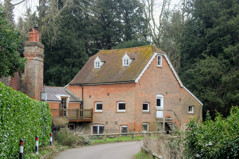
No 33, The Mill Pottery
(Formerly listed as Brattle's Mill, MILL LANE)
GV
II
Former watermill. Mid C19. Red brick with plain tiled half-hipped roof and two dormers. Catslide roofed extension to south. Later gabled wing to north with wooden gallery to west. Wooden mill-wheel in place on north side of main block. Segment headed surrounds to C20 easement windows. Door at west end of main block up eight wooden steps. Machinery awaiting reassembly at time of resurvey.
Listing NGR: TQ6860253600
External links are from the relevant listing authority and, where applicable, Wikidata. Wikidata IDs may be related buildings as well as this specific building. If you want to add or update a link, you will need to do so by editing the Wikidata entry.


Other nearby listed buildings
