Approximate Location Map
Large Map »
Latitude: 51.3049 / 51°18'17"N
Longitude: 0.4713 / 0°28'16"E
OS Eastings: 572358
OS Northings: 159092
OS Grid: TQ723590
Mapcode National: GBR PQR.5Y7
Mapcode Global: VHJM6.3GZK
Plus Code: 9F328F3C+WG
Entry Name: Court Lodge Farmhouse
Listing Date: 25 February 1987
Grade: II
Source: Historic England
Source ID: 1363082
English Heritage Legacy ID: 179204
ID on this website: 101363082
Location: Millhall, Tonbridge and Malling, Kent, ME20
County: Kent
District: Tonbridge and Malling
Civil Parish: Aylesford
Built-Up Area: Ditton
Traditional County: Kent
Lieutenancy Area (Ceremonial County): Kent
Church of England Parish: Aylesford St Peter and St Paul
Church of England Diocese: Rochester
Tagged with: Farmhouse
AYLESFORD CP BULL LANE
TQ 7259
(east side)
11/23
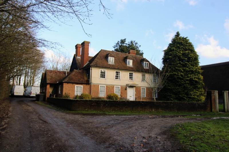
Court Lodge Farmhouse
-
GV II
Farmhouse. Late C17. Timber-framed, with red brick ground floor and rendered
first floor. Boxed wooden cornice and bracketted gutter to plain tiled hipped
roof with slope stacks to left and right ends and end stack to left. 2 hipped
dormers. 2 storeys and attics; regular 5-window front, glazing bar sashes
except metal-frame windows to left on ground floor. Central panelled door.
Listing NGR: TQ7235759093
External links are from the relevant listing authority and, where applicable, Wikidata. Wikidata IDs may be related buildings as well as this specific building. If you want to add or update a link, you will need to do so by editing the Wikidata entry.


Other nearby listed buildings
