Latitude: 51.2244 / 51°13'27"N
Longitude: 0.2137 / 0°12'49"E
OS Eastings: 554678
OS Northings: 149570
OS Grid: TQ546495
Mapcode National: GBR MNR.0W9
Mapcode Global: VHHPZ.NHC7
Plus Code: 9F3266F7+PF
Entry Name: Mansers Farmhouse
Listing Date: 19 February 1990
Grade: II
Source: Historic England
Source ID: 1363153
English Heritage Legacy ID: 179606
ID on this website: 101363153
Location: Tonbridge and Malling, Kent, TN11
County: Kent
District: Tonbridge and Malling
Civil Parish: Hildenborough
Traditional County: Kent
Lieutenancy Area (Ceremonial County): Kent
Church of England Parish: Hildenborough St John the Evangelist
Church of England Diocese: Rochester
Tagged with: Farmhouse
HILDENBOROUGH NIZELS LANE (west side) ) TQ 54 NW 4/173 Mansers Farmhouse
GV II
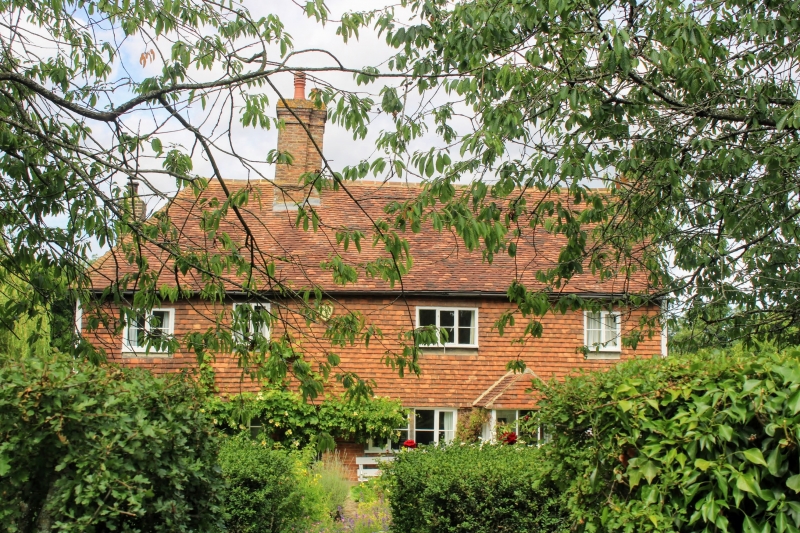
Former farmhouse. Circa early C17 or earlier with minor C19 and C20 additions. The early phase is of framed construction with brick nogging to the ground floor, the first floor tile-hung; peg-tile roof; brick stack.
Plan and Development: The house faces east. The original plan was a single- depth range, 3 rooms wide with a large room in the centre heated from an axial stack at the left (south) end. The quality of the carpentry in this room suggests a parlour/hall function rather than a kitchen, but neither of the outer rooms are heated - perhaps the original kitchen was detached. The service room to the south was originally very narrow and has been extended, probably in the C19. The north service room is larger and has a probably C19 stack added at the north end. The present entrance is direct into the centre room, at the north end but may originally have been into a lobby against the axial stack. There is some evidence that the original stair rose against the front (east) wall of the larger service room. C20 alterations include an axial passage taken out of the centre room, against the rear wall with a rear stair projection off the passage. A 1-room plan single-storey north west wing was also added, at right angles to the main range. This was originally heated (chimney shaft dismantled) and is said to have been used as separate accommodation for a dairyman (information from owners). The roof of the house was entirely reply ad in the late C19/C20.
Exterior: 2 storeys. Asymmetrical 4-window front with a late C19 or C20 porch with a hipped roof to right of centre. Set of 2- and 3-light late C19 or C20 timber casements, 2-panes per light with paired casements lighting the centre room and a 3-light C20 bay window to the extreme right. On the right return there is a section of diagonally-laid brick to the infill, partly obscured by the added projecting stack. The C20 rear wing has a lean-to roof. Roof hipped at left end gabled at right end. Stack with staggered shafts with corbelled brick cornices.
Interior: Rich in original carpentry, much of the framing, of large scantling, exposed. The centre ground floor room has a C17 open fireplace with chamfered stone jambs and a chamfered oak lintel. The longitudinal ceiling beam and exposed joists are chamfered and stopped. The right hand (north) room also has a chamfered, stopped crossbeam and exposed joists, but of a rather plainer character. This room was used as a dairy within living memory. A blocked doorway on the partition wall between the centre and right hand rooms may have been a doorway to the original stair. The left (south) service room retains evidence of the original end wall, which incorporated a ground floor window with timber stanchions. It is not clear whether the chamber over the centre room was heated originally: there is a recess in the wall but redundant mortises suggest that the framed partition was originally continuous. The wall framing has wall posts with roughly-dressed jowls and has curved up and down braces, some have been removed.
Roof: A complete replacement of the late C19 or C20 with no evidence of an earlier structure seen at time of survey (1988). A traditional house of the region with a well-preserved interior. Group value with Mansers (q.v.) opposite and to the east; Mansers was the original farmyard to Mansers Farmhouse, the buildings converted to residential use in the 1930s.
Listing NGR: TQ5467849570
External links are from the relevant listing authority and, where applicable, Wikidata. Wikidata IDs may be related buildings as well as this specific building. If you want to add or update a link, you will need to do so by editing the Wikidata entry.


Other nearby listed buildings