Approximate Location Map
Large Map »
Latitude: 51.3212 / 51°19'16"N
Longitude: -2.2088 / 2°12'31"W
OS Eastings: 385548
OS Northings: 158030
OS Grid: ST855580
Mapcode National: GBR 1ST.0DN
Mapcode Global: VH972.N2P0
Plus Code: 9C3V8QCR+FF
Entry Name: 14, Fore Street
Listing Date: 26 November 1976
Grade: II
Source: Historic England
Source ID: 1364225
English Heritage Legacy ID: 313985
ID on this website: 101364225
Location: Trowbridge, Wiltshire, BA14
County: Wiltshire
Civil Parish: Trowbridge
Built-Up Area: Trowbridge
Traditional County: Wiltshire
Lieutenancy Area (Ceremonial County): Wiltshire
Church of England Parish: Trowbridge St James
Church of England Diocese: Salisbury
Tagged with: Building
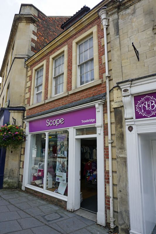
FORE STREET
1.
5411
(South West Side)
No 14
ST 8558 5/243
II GV
2.
Late C17/early C18 2 storey and attic painted brick house with rustic stone quoins
and sagging eaves cornice. Double roman tiles to steep pitched roof, crest ramped
to left with thick brick chimney behind. 1 glazing bar sash dormer. Three 1st
floor windows, centre blind, outer with thick glazing bar sashes and wide surrounds,
inner edges beaded outer moulded. Plain shop front on ground floor. 2 storey
brick extension to rear with 2 original windows and a later extension.
Nos 13 to 18 (consec) form a group. No 18 is of local interest.
Listing NGR: ST8554858030
External links are from the relevant listing authority and, where applicable, Wikidata. Wikidata IDs may be related buildings as well as this specific building. If you want to add or update a link, you will need to do so by editing the Wikidata entry.


Other nearby listed buildings
