Latitude: 51.1714 / 51°10'17"N
Longitude: -2.2579 / 2°15'28"W
OS Eastings: 382062
OS Northings: 141382
OS Grid: ST820413
Mapcode National: GBR 0T4.KY3
Mapcode Global: VH97M.TT5C
Plus Code: 9C3V5PCR+HR
Entry Name: Line and Unidentified Monuments in the Churchyard Between 16 and 18 Metres South of Church of St John the Baptist
Listing Date: 1 July 1986
Grade: II
Source: Historic England
Source ID: 1364358
English Heritage Legacy ID: 313337
ID on this website: 101364358
Location: St John the Baptist's Church, Newbury, Wiltshire, BA12
County: Wiltshire
Civil Parish: Horningsham
Traditional County: Wiltshire
Lieutenancy Area (Ceremonial County): Wiltshire
Church of England Parish: The Deverills and Horningsham
Church of England Diocese: Salisbury
Tagged with: Monument
HORNINGSHAM CHURCH LANE
ST 84 SW
(east side)
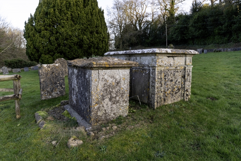
2/116 Line and unidentified monuments
in the churchyard between 16 and
18 metres south of Church of
St. John the Baptist
GV II
Two chest tombs. Mid C18. Limestone. South of pair has two
fielded panels and fielded pilasters to entablature with moulded
flat top, Ann Line died 1754. South of pair is plainer with
illegible inscription, ivy covered at time of survey (June 1985).
Listing NGR: ST8206241382
External links are from the relevant listing authority and, where applicable, Wikidata. Wikidata IDs may be related buildings as well as this specific building. If you want to add or update a link, you will need to do so by editing the Wikidata entry.


Other nearby listed buildings