Latitude: 52.3486 / 52°20'55"N
Longitude: -1.5893 / 1°35'21"W
OS Eastings: 428072
OS Northings: 272365
OS Grid: SP280723
Mapcode National: GBR 5LC.M0V
Mapcode Global: VHBX9.D7NC
Plus Code: 9C4W8CX6+F7
Entry Name: 19, Castle Hill
Listing Date: 24 November 1970
Grade: II
Source: Historic England
Source ID: 1364901
English Heritage Legacy ID: 307769
ID on this website: 101364901
Location: Castle Green, Warwick, Warwickshire, CV8
County: Warwickshire
District: Warwick
Civil Parish: Kenilworth
Built-Up Area: Kenilworth
Traditional County: Warwickshire
Lieutenancy Area (Ceremonial County): Warwickshire
Church of England Parish: Kenilworth St Nicholas
Church of England Diocese: Coventry
Tagged with: Building
This list entry was subject to a Minor Amendment on 28/10/2011
SP 2872 SW 5/62
1270
24.11.70
CASTLE HILL
(South Side)
Little Virginia
No 19
(Formerly listed as Little Virginia Nos 23 and 25)
GV
II
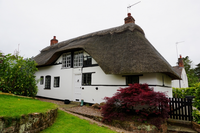
C17 or C18. Red brick with some exposed timber framing, thatched
roof. One storey and attics, flush casement windows.
Nos 5 to 35 (odd) form a group.
Listing NGR: SP2807272365
External links are from the relevant listing authority and, where applicable, Wikidata. Wikidata IDs may be related buildings as well as this specific building. If you want to add or update a link, you will need to do so by editing the Wikidata entry.


Other nearby listed buildings