Approximate Location Map
Large Map »
Latitude: 52.3713 / 52°22'16"N
Longitude: -1.2605 / 1°15'37"W
OS Eastings: 450442
OS Northings: 275064
OS Grid: SP504750
Mapcode National: GBR 8QL.651
Mapcode Global: VHCTR.3NGJ
Plus Code: 9C4W9PCQ+GQ
Entry Name: 2, Church Walk
Listing Date: 3 September 1976
Grade: II
Source: Historic England
Source ID: 1365003
English Heritage Legacy ID: 308446
ID on this website: 101365003
Location: Rugby, Warwickshire, CV21
County: Warwickshire
District: Rugby
Electoral Ward/Division: Eastlands
Parish: Non Civil Parish
Built-Up Area: Rugby
Traditional County: Warwickshire
Lieutenancy Area (Ceremonial County): Warwickshire
Church of England Parish: Rugby St Andrew
Church of England Diocese: Coventry
Tagged with: Building
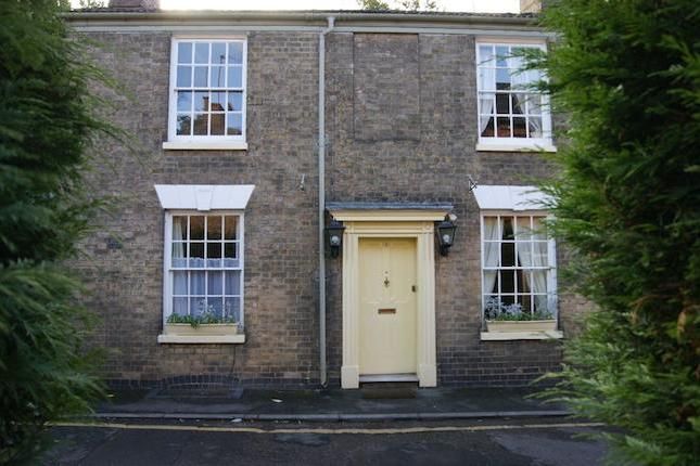
CHURCH WALK
1.
5397
(West Side)
No 2
SP 5075 SW 1/64
II
2.
Earlier C19, circa 1830-40. Yellow brick, hipped Welsh slated roof with bracketed
eaves cornice. 2 storeys, 3 sash windows with glazing bars under stucco keyblocks
and rusticated lintels. 5 panelled central door and rectangular fanlight with geometrical
glazing bars in Doric porch with pillars, pilasters and entablature. Stucco segmental
bow window on left of ground floor.
Listing NGR: SP5044275064
External links are from the relevant listing authority and, where applicable, Wikidata. Wikidata IDs may be related buildings as well as this specific building. If you want to add or update a link, you will need to do so by editing the Wikidata entry.


Other nearby listed buildings
