Latitude: 50.7005 / 50°42'1"N
Longitude: -1.2923 / 1°17'32"W
OS Eastings: 450072
OS Northings: 89227
OS Grid: SZ500892
Mapcode National: GBR 8BB.XSG
Mapcode Global: FRA 8757.B9Y
Plus Code: 9C2WPP25+63
Entry Name: 143 High Street
Listing Date: 1 February 1972
Last Amended: 26 February 2024
Grade: II
Source: Historic England
Source ID: 1365246
English Heritage Legacy ID: 309568
ID on this website: 101365246
Location: Newport, Isle of Wight, PO30
County: Isle of Wight
Civil Parish: Newport
Built-Up Area: Newport
Traditional County: Hampshire
Lieutenancy Area (Ceremonial County): Isle of Wight
Church of England Parish: Newport St Thomas
Church of England Diocese: Portsmouth
Tagged with: Building
Former terraced shop, now offices. Built in around the late C18 with alterations in about the mid-C20.
Former terraced shop, now offices. Built in around the late C18 with alterations in about the mid-C20.
MATERIALS: faced in purple-grey brick with red brick dressings. Slate roof coverings.
PLAN: a rectangular plan three-storey terraced building with a shopfront to the ground floor and offices above.
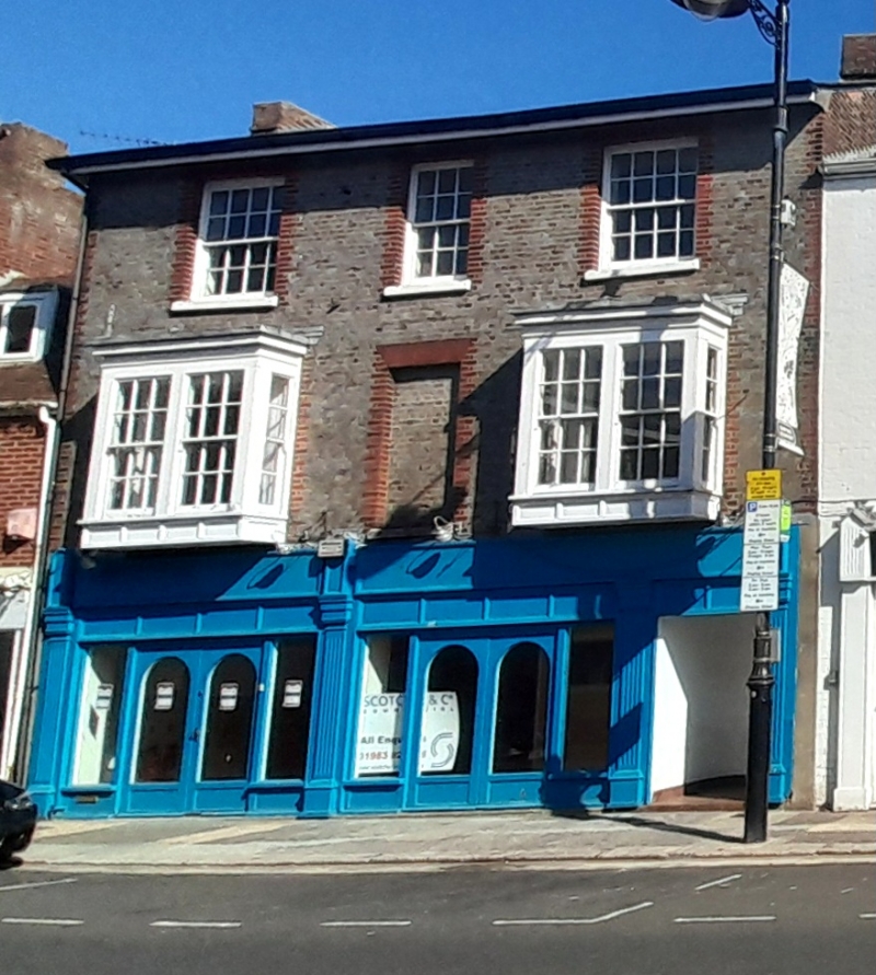
EXTERIOR: 143 High Street is three storeys high and three bays wide, fronting directly onto the High Street. It is faced in purple-grey bricks, laid in header bond, with red brick window dressings, flat arch lintels above the windows and decorative brick quoins. The ground floor is occupied by a shopfront which is of three bays separated by fluted Doric pilasters; the western two bays each have glazed double doors flanked by plate glass shop windows whilst the eastern bay has a tiled porch leading to a six-panelled door giving additional access to the offices above. A fascia panel carrying the shop signage runs across the top of the ground floor frontage. At first floor level there are two rectangular timber oriel windows flanking a central, narrow blind (blocked) window opening with a stone cill. The side faces of the two oriel windows contain two-over-two sashes whilst the front face consists of a pair of six-over-six sashes. The sashes are separated by plain strips and bounded by a panelled apron, plain frieze and cornice. There are three recessed sash windows with stone cills to the second floor. Those in the first and third bay are eight-over-eight sashes whilst the central bay has a six-over-six sash. Above the second-floor is a wooden eaves cornice. 143 High Street has a gabled roof covered in slates with two brick chimney stacks at each end. The west gable end has a C19 painted shop sign: 'SELF pastry cook. THE NOTED PIE SHOP'.
Newport’s first charter was granted by Richard de Redvers, fourth Earl of Devon in the late C12 and this is generally regarded as marking its foundation. The settlement was laid out on the low-lying ground along the western bank of the River Medina using a grid-style plan. Recent topographic analysis suggests that Newport may have developed around an existing informal trading settlement located at the head of the Medina estuary, in the vicinity of Sea and Quay Street (Alexander, 2021). The High Street is one of five east-west running streets within the grid layout. High Street and Pyle Street extend the full length of the grid, divided by a market square, and form the planned core of Newport, with other shorter parallel streets to the south (South Street) and north (Lugley and Crocker Street). They were all largely in place by the mid-C13.
In the C14, the Isle of Wight was frequently subject to raids by French forces during long-running conflicts between England and France. According to historical documents, during one of the raids in 1377 Newport was severely damaged by fire and much of the population fled to Carisbrooke Castle. It appears that Newport was functioning again a few years later. During this century, records indicate that the population of Newport did decrease, most likely due to several wider economic factors, and did not significantly increase until the mid-C17. The town was incorporated as a borough in 1608 under a new charter granted by James I. Newport did not significantly expand beyond its medieval limits until around the late C18. By the mid-C19 there had been a more significant expansion of the town, including the development of its suburbs, which continued into the C20.
143 High Street was built in around the late C18 and is first shown on the 1864 Ordnance Survey (OS) map. At this time, it appears to have included a central carriageway or passageway leading from the High Street to a small, central courtyard which the building wrapped around to the north and northeast. An 1898 article in the Isle of Wight County Press and South of England Reporter states that 143 High Street was occupied by John Dawson Self, a restaurant-keeper and confectioner. The surviving painted sign on the west gable advertises Self’s ‘noted pie shop’. By the late 1960s, the OS maps indicate that the ground floor carriageway or passageway had been infilled. In 2017, the building was converted to a solicitor’s office.
143 High Street is listed at Grade II for the following principal reasons:
Architectural interest:
* as a late C18 building which contributes to the character of an architecturally varied historic streetscape.
Historic interest:
* as part of the urban development of Newport’s historic core.
Group value:
* the building is in close proximity to a large number of listed buildings and forms part of a strong historic grouping.
External links are from the relevant listing authority and, where applicable, Wikidata. Wikidata IDs may be related buildings as well as this specific building. If you want to add or update a link, you will need to do so by editing the Wikidata entry.


Other nearby listed buildings