Approximate Location Map
Large Map »
Latitude: 51.4203 / 51°25'13"N
Longitude: -1.73 / 1°43'48"W
OS Eastings: 418867
OS Northings: 169071
OS Grid: SU188690
Mapcode National: GBR 4X2.TP9
Mapcode Global: VHB46.YKRJ
Plus Code: 9C3WC7C9+4X
Entry Name: 1-10, Alma Place
Listing Date: 21 October 1974
Grade: II
Source: Historic England
Source ID: 1365377
English Heritage Legacy ID: 310252
ID on this website: 101365377
Location: Marlborough, Wiltshire, SN8
County: Wiltshire
Civil Parish: Marlborough
Built-Up Area: Marlborough
Traditional County: Wiltshire
Lieutenancy Area (Ceremonial County): Wiltshire
Tagged with: Terrace of houses
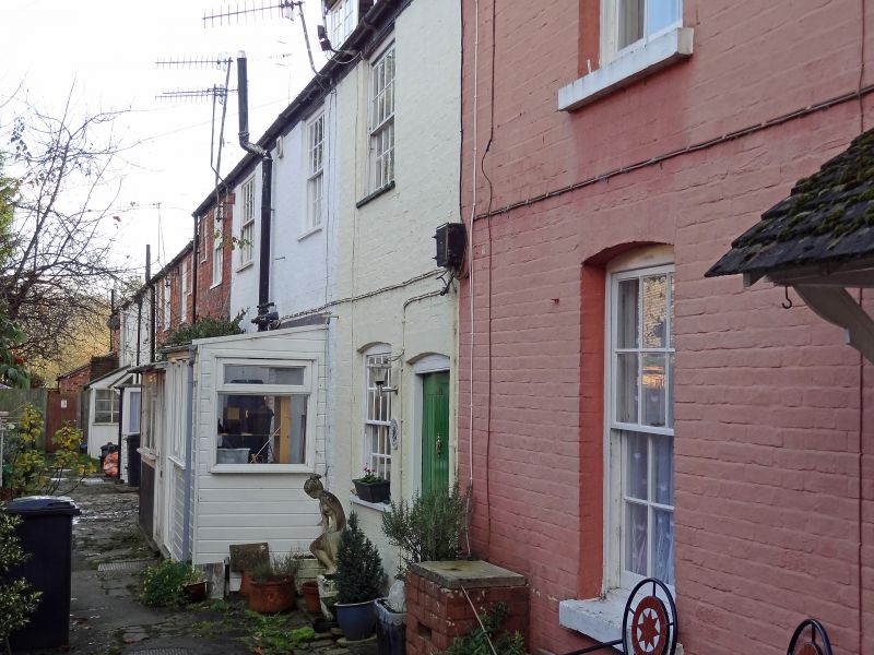
ALMA PLACE
1.
5407
(West Side)
Nos 1 to l0 (consec)
SU 1869 1/130
II
GV
2.
C18. Chequer brick (some colour washed). Pitched old tile roof. Brick stacks.
1 range each of cased sashes with glazing bars (No 1 has ground floor casement,
Nos 3 and 8 modern casements). 1 planked door each, except for No 2 which is
four-panelled, and Nos 1, 4, 7 & 8, which are modern. Later porches to Nos 2,
3, 4, 8 and 9.
All the listed items in Alma Place form a group.
Listing NGR: SU1887969059
External links are from the relevant listing authority and, where applicable, Wikidata. Wikidata IDs may be related buildings as well as this specific building. If you want to add or update a link, you will need to do so by editing the Wikidata entry.


Other nearby listed buildings
