Latitude: 51.4225 / 51°25'20"N
Longitude: -1.73 / 1°43'48"W
OS Eastings: 418866
OS Northings: 169306
OS Grid: SU188693
Mapcode National: GBR 4X2.MG5
Mapcode Global: VHB46.YHRX
Plus Code: 9C3WC7C9+XX
Entry Name: 38 and 39, Kingsbury Street
Listing Date: 21 October 1974
Grade: II
Source: Historic England
Source ID: 1365408
English Heritage Legacy ID: 310413
ID on this website: 101365408
Location: Marlborough, Wiltshire, SN8
County: Wiltshire
Civil Parish: Marlborough
Built-Up Area: Marlborough
Traditional County: Wiltshire
Lieutenancy Area (Ceremonial County): Wiltshire
Tagged with: Building
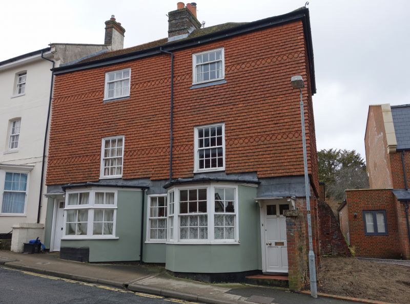
KINGSBURY STREET 1. 5407 (East side) Nos 38 & 39 SU 1869 1/218 II 2. C18. Rendered. Tile-hung side. Hipped old tile roof. Red brick stack. 3 storeys. 2 ranges of sashes with glazing bars in moulded flush frames. Ground floor has 2 canted bays, No 39's with with moulded cornice and sashes with glazing bars, No 38's with renewed fenestration. 1 modern door each, under original hood (No 38's moulded) on cut brackets. 1 modern sash between the bays. 2 sashes with glazing bars in side.
Listing NGR: SU1886969308
External links are from the relevant listing authority and, where applicable, Wikidata. Wikidata IDs may be related buildings as well as this specific building. If you want to add or update a link, you will need to do so by editing the Wikidata entry.


Other nearby listed buildings