Latitude: 51.4317 / 51°25'54"N
Longitude: -1.5373 / 1°32'14"W
OS Eastings: 432260
OS Northings: 170406
OS Grid: SU322704
Mapcode National: GBR 6ZZ.25D
Mapcode Global: VHC1S.98MR
Plus Code: 9C3WCFJ7+M3
Entry Name: Stud Farmhouse
Listing Date: 6 March 1985
Grade: II
Source: Historic England
Source ID: 1365459
English Heritage Legacy ID: 310590
ID on this website: 101365459
Location: Chilton Foliat, Wiltshire, RG17
County: Wiltshire
Civil Parish: Chilton Foliat
Built-Up Area: Chilton Foliat
Traditional County: Wiltshire
Lieutenancy Area (Ceremonial County): Wiltshire
Tagged with: Farmhouse
SU 37 SW CHILTON FOLIAT A.419
(north side)
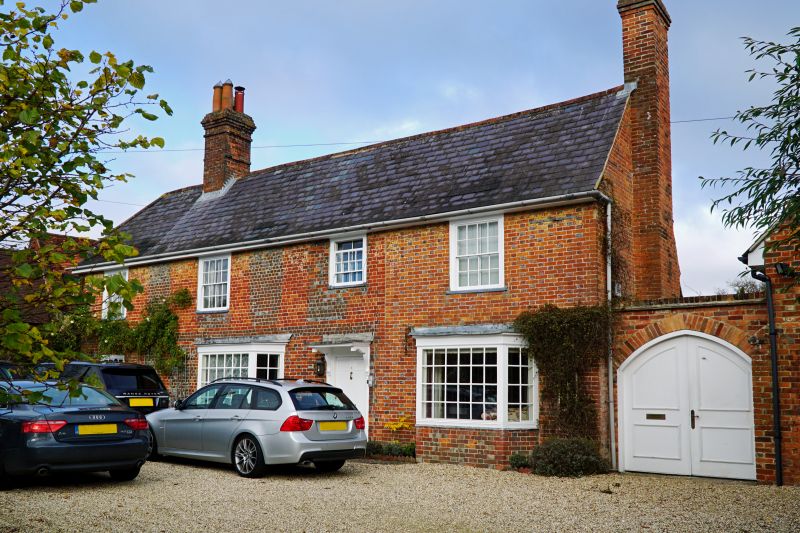
5/127 Stud Farmhouse
II
House. C18-C19. Red and vitrified blue patterned brick. Slate
roof. 2-storey, 3 bays, extended right by 1 bay. 6-panelled door
with bracketed canopy in 3rd bay, C20 canted bay to left, and in
right extension. Other windows 16-pane sashes. Stack between bays
1 and 2, and on right gable. Roof half hipped left.
Listing NGR: SU3226070406
External links are from the relevant listing authority and, where applicable, Wikidata. Wikidata IDs may be related buildings as well as this specific building. If you want to add or update a link, you will need to do so by editing the Wikidata entry.


Other nearby listed buildings