Approximate Location Map
Large Map »
Latitude: 51.2434 / 51°14'36"N
Longitude: 0.9626 / 0°57'45"E
OS Eastings: 606875
OS Northings: 153528
OS Grid: TR068535
Mapcode National: GBR SWZ.XX8
Mapcode Global: VHKK9.M0QM
Plus Code: 9F326XV7+92
Entry Name: St Mary's Church of England Primary School and Wall to North
Listing Date: 13 August 1984
Grade: II
Source: Historic England
Source ID: 1366080
English Heritage Legacy ID: 181470
ID on this website: 101366080
Location: Chilham, Ashford, Kent, CT4
County: Kent
District: Ashford
Civil Parish: Chilham
Built-Up Area: Chilham
Traditional County: Kent
Lieutenancy Area (Ceremonial County): Kent
Tagged with: Architectural structure
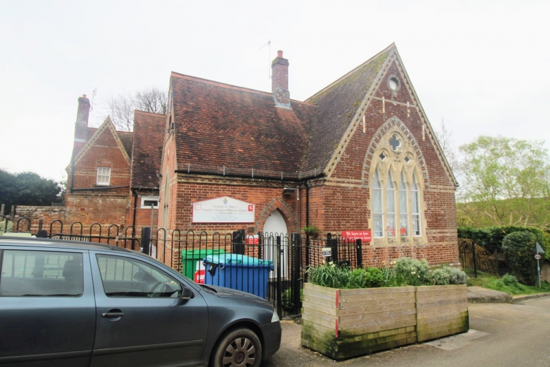
TR 0653-0753 CHILHAM SCHOOL HILL
(north-east side)
7/41 St. Mary's C.E.
Primary School and
wall to north
GV II
School. 1862. H. Blandford. Entrance (playground) front:
red brick with yellow brick bands and polychrome arch heads.
Plain tile roof. Continuous plinth, bands and modillion eaves
cornice. 3 gables to playground, with irregular fenestration
of plate glass windows with polychrome arches, a collection
of 4 tall lancets in the centre gable. Stacks to centre, to
right and corbelled projecting stack end left gable. Entrance
in re-entrant angle of right gable and end gable of south
(right side) front - arched plank door in polychrome opening.
A portion of the playground wall attached to pentice centre
left is also of red and yellow buttressed and banded brick,
extending 7 yards north of main building to an opening in the
wall. South (right side front): red and yellow banded
brick, plinth,eaves cornice, tile roof with 4 gables, and central
projecting gable, and 6 large 2 light windows. Central 2 light
window of ashlared plate tracery.
Listing NGR: TR0687553533
External links are from the relevant listing authority and, where applicable, Wikidata. Wikidata IDs may be related buildings as well as this specific building. If you want to add or update a link, you will need to do so by editing the Wikidata entry.


Other nearby listed buildings
