Latitude: 53.3883 / 53°23'17"N
Longitude: -1.2707 / 1°16'14"W
OS Eastings: 448602
OS Northings: 388191
OS Grid: SK486881
Mapcode National: GBR MYK8.P3
Mapcode Global: WHDDS.G348
Plus Code: 9C5W9PQH+8P
Entry Name: Town End Farmhouse
Listing Date: 29 March 1968
Last Amended: 1 April 1987
Grade: II
Source: Historic England
Source ID: 1366108
English Heritage Legacy ID: 335962
ID on this website: 101366108
Location: Brampton en le Morthen, Rotherham, South Yorkshire, S66
County: Rotherham
Civil Parish: Thurcroft
Traditional County: Yorkshire
Lieutenancy Area (Ceremonial County): South Yorkshire
Church of England Parish: Thurcroft St Simon and St Jude
Church of England Diocese: Sheffield
Tagged with: Farmhouse
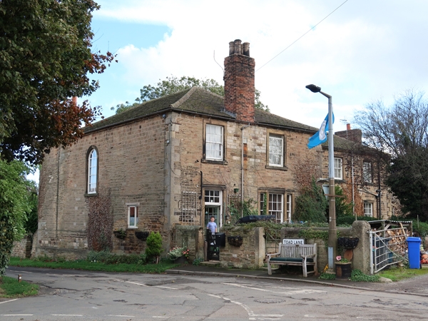
THURCROFT BRAMPTON-EN-LE-MORTHEN SK48NE 6/87 Town end Farmhouse 29.3.68 [formerly listed as part of Ash Farm (house and barn)] GV II Farmhouse. c1800 and early C19. Thinly-coursed, dressed sandstone, C20 cement-tile roof. T-shaped plan. 2-storeys, 2:3 windows to 1st floor on (west) entrance front. Earlier cross-wing on left: chamfered plinth, large raised quoins; part-glazed door and 6-pane overlight in raised ashlar surround on left of tripartite sash window; sashes with glazing bars over have projecting sills to raised ashlar surrounds. Later wing set back on right: large quoins; blocked doorway flanked by sashes with glazing bars in raised ashlar surrounds, doorway with quoined surround to far left; 1st-floor windows as rest. Eaves band to hipped roofs of both ranges, brick stacks to eaves at each end and to front eaves of cross wing. Left return: round- headed stair window with Gothick glazing bars.
Listing NGR: SK4860288191
External links are from the relevant listing authority and, where applicable, Wikidata. Wikidata IDs may be related buildings as well as this specific building. If you want to add or update a link, you will need to do so by editing the Wikidata entry.


Other nearby listed buildings