Approximate Location Map
Large Map »
Latitude: 52.8555 / 52°51'19"N
Longitude: -2.7241 / 2°43'26"W
OS Eastings: 351336
OS Northings: 328912
OS Grid: SJ513289
Mapcode National: GBR 7J.S4T0
Mapcode Global: WH8B2.4H18
Plus Code: 9C4VV74G+58
Entry Name: 27, High Street
Listing Date: 6 June 1983
Grade: II
Source: Historic England
Source ID: 1366757
English Heritage Legacy ID: 259935
ID on this website: 101366757
Location: Wem, Shropshire, SY4
County: Shropshire
Civil Parish: Wem Urban
Built-Up Area: Wem
Traditional County: Shropshire
Lieutenancy Area (Ceremonial County): Shropshire
Church of England Parish: Wem St Peter and St Paul
Church of England Diocese: Lichfield
Tagged with: Building
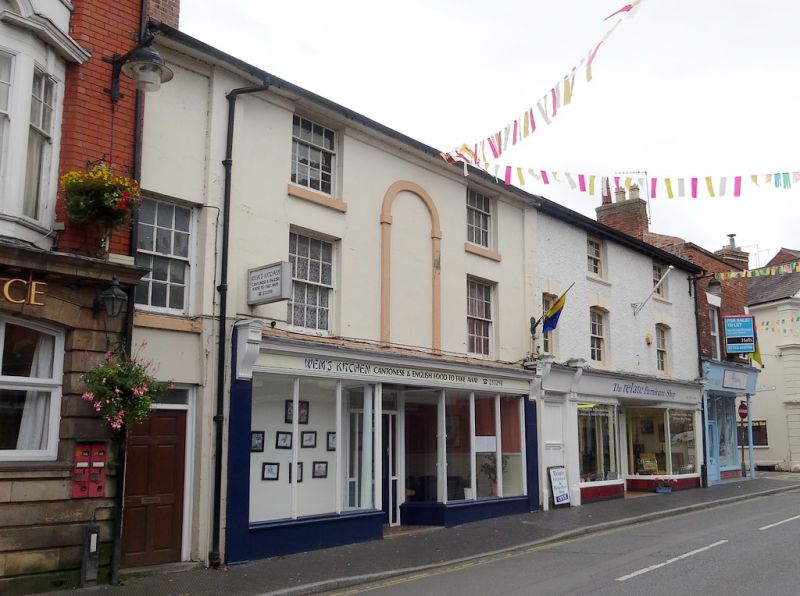
1.
5358 HIGH STREET
(south side)
No 27
SJ 5128 3/28
II GV
2.
Early C19 stuccoed building. Welsh slate roof with gabled ends and slightly over-
sailing eaves. Three storeys. Three bays. Sashes with glazing bars, centre bay
has 2-storey blind panel with round head. Quoin pilasters. Large Victorian shop
front.
Listing NGR: SJ5133628912
External links are from the relevant listing authority and, where applicable, Wikidata. Wikidata IDs may be related buildings as well as this specific building. If you want to add or update a link, you will need to do so by editing the Wikidata entry.


Other nearby listed buildings
