Approximate Location Map
Large Map »
Latitude: 51.4341 / 51°26'2"N
Longitude: 0.353 / 0°21'10"E
OS Eastings: 563651
OS Northings: 173198
OS Grid: TQ636731
Mapcode National: GBR NMR.02C
Mapcode Global: VHJLK.26GX
Plus Code: 9F32C9M3+M5
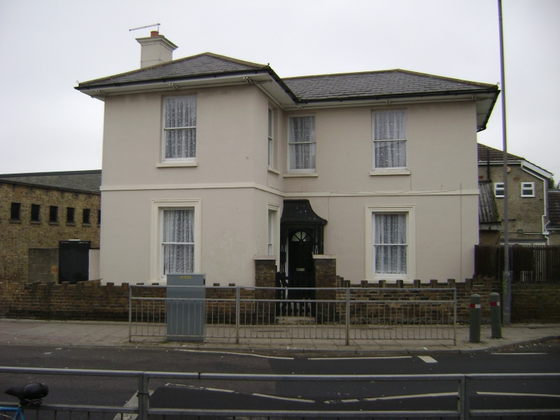
Entry Name: 2, Perry Street
Listing Date: 3 September 1979
Grade: II
Source: Historic England
Source ID: 1367426
English Heritage Legacy ID: 356850
ID on this website: 101367426
Location: Perry Street, Gravesham, Kent, DA11
County: Kent
District: Gravesham
Electoral Ward/Division: Northfleet South
Parish: Non Civil Parish
Built-Up Area: Northfleet
Traditional County: Kent
Lieutenancy Area (Ceremonial County): Kent
Church of England Parish: Perry Street, All Saints
Church of England Diocese: Rochester
Tagged with: Building
TQ 67 SW NORTHFLEET PERRY STREET
1/122
3.9.79 No 2
II
Circa 1840. Stuccoed L-shaped house with shallow pitched, hipped, slate roof and deep
eaves in Italianate early Victorian style. Four sash windows on ground floor with
moulded surrounds, 5 plain sash windows on first floor. Front door under small tented
canopy on trellis work supports in angle of L.
Listing NGR: TQ6365173198
External links are from the relevant listing authority and, where applicable, Wikidata. Wikidata IDs may be related buildings as well as this specific building. If you want to add or update a link, you will need to do so by editing the Wikidata entry.


Other nearby listed buildings
