Approximate Location Map
Large Map »
Latitude: 52.6368 / 52°38'12"N
Longitude: -2.2838 / 2°17'1"W
OS Eastings: 380891
OS Northings: 304376
OS Grid: SJ808043
Mapcode National: GBR 079.RDL
Mapcode Global: WH9DC.WZNF
Plus Code: 9C4VJPP8+PF
Entry Name: Shrewsbury Arms
Listing Date: 29 September 1951
Grade: II
Source: Historic England
Source ID: 1367615
English Heritage Legacy ID: 255129
ID on this website: 101367615
Location: Albrighton, Shropshire, WV7
County: Shropshire
Civil Parish: Albrighton
Built-Up Area: Albrighton
Traditional County: Shropshire
Lieutenancy Area (Ceremonial County): Shropshire
Church of England Parish: Albrighton St Mary Magdalene
Church of England Diocese: Lichfield
Tagged with: Pub
SJ 80 SW; 6/16
ALBRIGHTON C.P.,
HIGH STREET (south side),
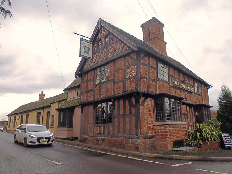
Shrewsbury Arms
29.09.51
G.V.
II
House, now inn. Late C15 or early C16 with later additions and
alterations. Half timbered on sandstone and brick plinth with C20
red brick nogging, plain tiled roofs. Hall (fragmentary) and cross-
wing type converted. The principal surviving feature is the front
to Church Road (cross wing) of three structural bays. Small square panelling
to first floor, close studding to ground, short tension braces;
continuous moulded jetty to first floor supported on four carved brackets,
two C20 projecting bays with leaded casements underneath, two C20 casements
to first floor. Prominent central quadripartite chimney with arched
dividing rebates and moulded capping on sandstone base. Left-hand
gable end has close studding to ground floor and square panelling to
first; continuation of the first floor jetty on four carved brackets
(three replacements, one with linked chain decoration); moulded jetty to
attic with lozenge shaped and decorative half timbering above; C20
casements. A fragment of the 'hall' fronts the High Street. Plastered;
two storeys with C20 casement to first floor and projecting extension
with entrance to front. Brick end stack. Sawn-off purlins projecting
from gable end show range has been truncated.
Listing NGR: SJ8089104376
External links are from the relevant listing authority and, where applicable, Wikidata. Wikidata IDs may be related buildings as well as this specific building. If you want to add or update a link, you will need to do so by editing the Wikidata entry.


Other nearby listed buildings
