Latitude: 51.7893 / 51°47'21"N
Longitude: -1.4825 / 1°28'57"W
OS Eastings: 435787
OS Northings: 210194
OS Grid: SP357101
Mapcode National: GBR 6VL.XNN
Mapcode Global: VHC02.8936
Plus Code: 9C3WQGQ8+PX
Entry Name: Bridge House
Listing Date: 6 February 1970
Last Amended: 3 March 1988
Grade: II
Source: Historic England
Source ID: 1367929
English Heritage Legacy ID: 252576
ID on this website: 101367929
Location: Woodgreen, West Oxfordshire, OX28
County: Oxfordshire
District: West Oxfordshire
Civil Parish: Witney
Built-Up Area: Witney
Traditional County: Oxfordshire
Lieutenancy Area (Ceremonial County): Oxfordshire
Church of England Parish: Witney
Church of England Diocese: Oxford
Tagged with: House
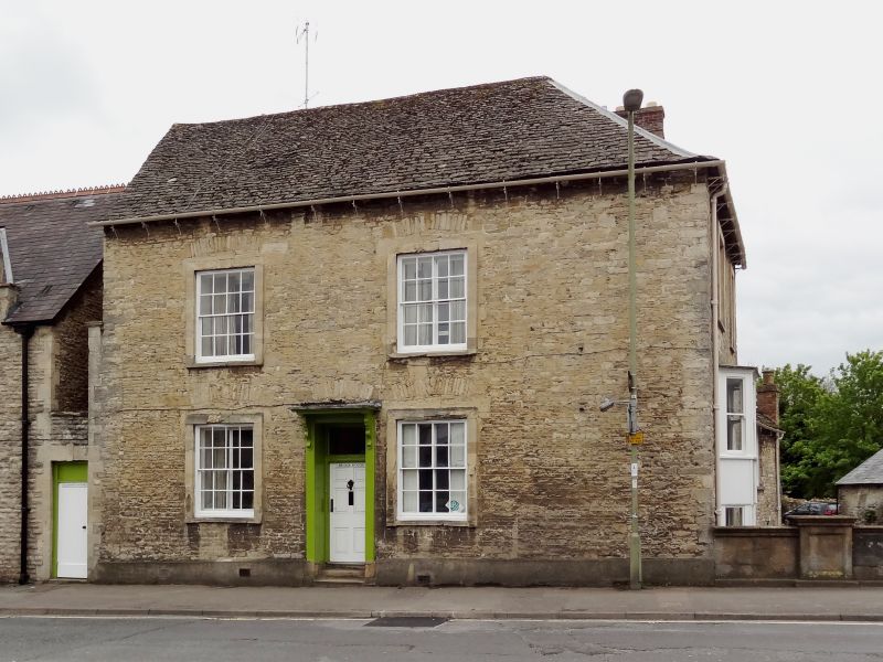
WITNEY BRIDGE STREET
SP3510SE (East side)
9/7 No,2 (Bridge House)
06/02/70 (Formerly listed as No.2)
GV II
House. Early C19, with earlier origins. Squared and coursed limestone; hipped
stone slate roof; brick rear lateral stack. L-plan with rear right wing. 2
storeys; 2-window range. Central early C19 six-panelled door with overlight set
in plain architrave with bracketed flat hood. 8-pane sashes set in plain stone
architraves with relieving arches. Mid C19 bay window to right side wall.
2-storey bay of similar materials and mid C19 service range to rear. Interior
not inspected but likely to be of interest.
Listing NGR: SP3578710194
External links are from the relevant listing authority and, where applicable, Wikidata. Wikidata IDs may be related buildings as well as this specific building. If you want to add or update a link, you will need to do so by editing the Wikidata entry.


Other nearby listed buildings