Latitude: 51.8468 / 51°50'48"N
Longitude: -1.3536 / 1°21'13"W
OS Eastings: 444621
OS Northings: 216659
OS Grid: SP446166
Mapcode National: GBR 7WJ.0MN
Mapcode Global: VHCX6.HV74
Plus Code: 9C3WRJWW+PG
Entry Name: 38 and 40, High Street
Listing Date: 13 February 1969
Last Amended: 27 July 1988
Grade: II
Source: Historic England
Source ID: 1368019
English Heritage Legacy ID: 253090
ID on this website: 101368019
Location: Woodstock, West Oxfordshire, OX20
County: Oxfordshire
District: West Oxfordshire
Civil Parish: Woodstock
Built-Up Area: Woodstock
Traditional County: Oxfordshire
Lieutenancy Area (Ceremonial County): Oxfordshire
Church of England Parish: Woodstock
Church of England Diocese: Oxford
Tagged with: Building
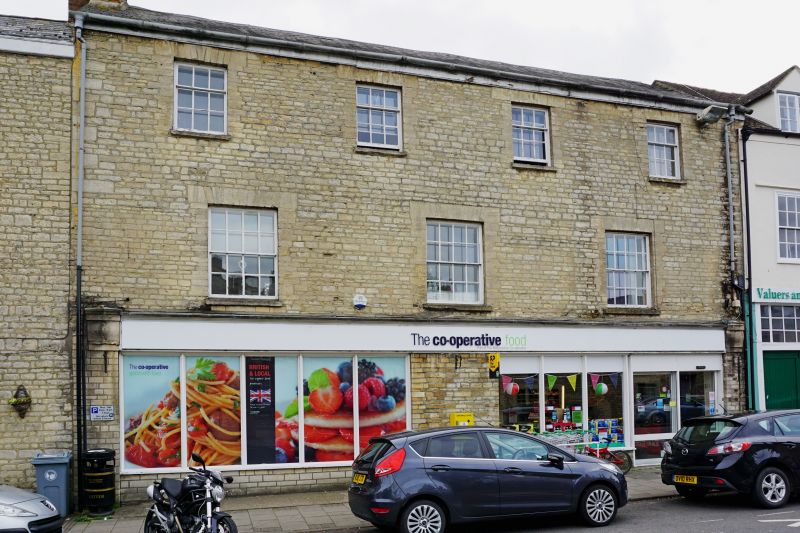
WOODSTOCK HIGH STREET
SP4416NE (South side)
10/98 Nos.38 and 40
13/02/69 (Formerly listed as No.38,
No.40)
GV II
House, now supermarket and flats. Early C19. Squared and coursed limestone;
gabled Welsh slate roof; brick end stack. Double-depth plan. 3 storeys; 4-window
range. C20 shop windows to ground floor. Flat stone arches over 3 eight-pane
sashes on first floor and 4 three-over-6 pane sashes on second floor. Interior
not inspected. Included for group value.
Listing NGR: SP4462116659
External links are from the relevant listing authority and, where applicable, Wikidata. Wikidata IDs may be related buildings as well as this specific building. If you want to add or update a link, you will need to do so by editing the Wikidata entry.


Other nearby listed buildings