Latitude: 51.7467 / 51°44'48"N
Longitude: -0.9776 / 0°58'39"W
OS Eastings: 470683
OS Northings: 205829
OS Grid: SP706058
Mapcode National: GBR B0T.KN2
Mapcode Global: VHDVG.0CK9
Plus Code: 9C3XP2WC+MX
Entry Name: Lloyds Bank Limited
Listing Date: 8 June 1970
Last Amended: 16 June 1988
Grade: II
Source: Historic England
Source ID: 1368761
English Heritage Legacy ID: 248472
ID on this website: 101368761
Location: Thame, South Oxfordshire, OX9
County: Oxfordshire
District: South Oxfordshire
Civil Parish: Thame
Built-Up Area: Thame
Traditional County: Oxfordshire
Lieutenancy Area (Ceremonial County): Oxfordshire
Church of England Parish: Thame St Mary
Church of England Diocese: Oxford
Tagged with: Bank building
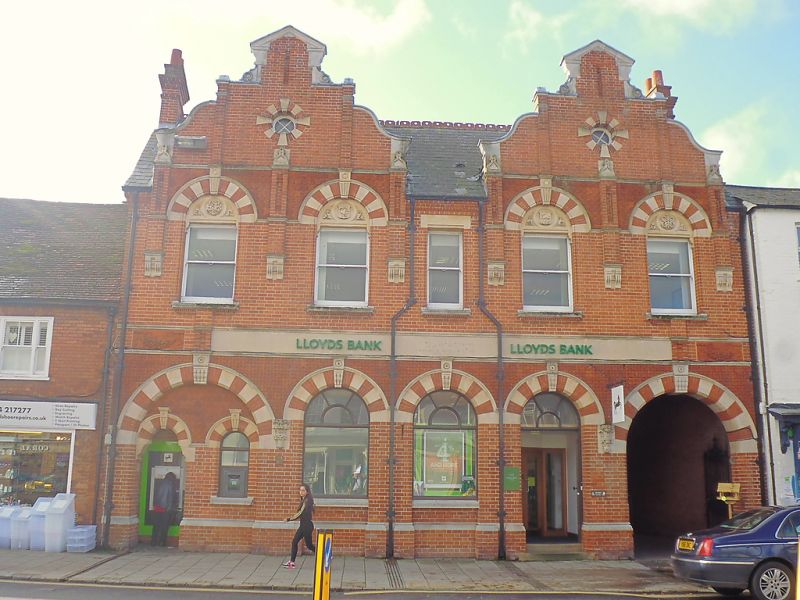
THAME CORNMARKET SP7005NE (South-west side) 10/45 Nos.13 and 14 (Lloyds Bank 08/06/70 Limited) (Formerly listed as Nos.13 and 14 (Lloyd's Bank)
GV II
Bank. c.1890, with C20 alterations. Red brick with yellow brick and stone dressings, and moulded terracotta panels; old plain-tile roof; brick end stacks. Pont-Street-Dutch style. 2 storeys and attic; 5-window range. C20 plank door with fanlight to right of centre, with round-arched head with yellow and red voussoirs. C19 round-arched windows to left of centre and centre with round arched heads with yellow and red brick voussoirs. Carriageway arch to right with yellow and red brick voussoirs. Blind arch to left having smaller archway to left and single-light window to right, all with yellow and red brick voussoirs. Horned sashes without glazing bars to first floor, all except that to centre having blind tympani with round relieving arches with yellow and brick voussoirs. 2 Dutch cross-gables to attic. Interior C20 alterations to banking hall.
Listing NGR: SP7068005815
External links are from the relevant listing authority and, where applicable, Wikidata. Wikidata IDs may be related buildings as well as this specific building. If you want to add or update a link, you will need to do so by editing the Wikidata entry.


Other nearby listed buildings