Approximate Location Map
Large Map »
Latitude: 51.5378 / 51°32'16"N
Longitude: -0.9031 / 0°54'11"W
OS Eastings: 476173
OS Northings: 182671
OS Grid: SU761826
Mapcode National: GBR C4S.DJ5
Mapcode Global: VHDWG.9LFZ
Plus Code: 9C3XG3QW+4Q
Entry Name: Blandy House
Listing Date: 25 January 1951
Grade: II
Source: Historic England
Source ID: 1369134
English Heritage Legacy ID: 246189
ID on this website: 101369134
Location: Henley-on-Thames, South Oxfordshire, RG9
County: Oxfordshire
District: South Oxfordshire
Civil Parish: Henley-on-Thames
Built-Up Area: Henley-on-Thames
Traditional County: Oxfordshire
Lieutenancy Area (Ceremonial County): Oxfordshire
Church of England Parish: Henley-on-Thames
Church of England Diocese: Oxford
Tagged with: House
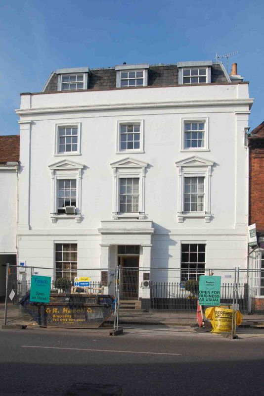
1. HART STREET
5355 (North Side)
No 29 (Blandy House)
SU 7582 1/49 25.1.51.
II GV
2.
Early C19. Colourwashed stucco with rusticated ground floor. Moulded
string. Corner pilasters to 1st and 2nd floors. Eaves cornice with plain
frieze below and blocking course above. Roof not visible. 3 storeys,
3 windows, all sashes with glazing bars. Those of lst floor with bracketed
sills and pediments, those of both upper floors with moulded architraves.
Central doorway with advanced square pillars, cornice and blocking course.
Moulded string carried around door head, 6 panelled door. Rectangular
fanlight. Contemporary iron area railings with spear head finials.
Nos 5 to 39 (odd), the Drinking Fountain, the Parish Church of St Mary
and the raised pavement at the east end of Hart Street, form a group associated
with Nos 2 to 8 (even) Nos 14 to 36 (even) including Adam House and Nos
40, 44 (including gates and piers) 48, No 50, The Old School House and
the Rectory Garden Wall opposite.
Listing NGR: SU7617382671
External links are from the relevant listing authority and, where applicable, Wikidata. Wikidata IDs may be related buildings as well as this specific building. If you want to add or update a link, you will need to do so by editing the Wikidata entry.


Other nearby listed buildings
