Approximate Location Map
Large Map »
Latitude: 51.7543 / 51°45'15"N
Longitude: -1.2582 / 1°15'29"W
OS Eastings: 451302
OS Northings: 206441
OS Grid: SP513064
Mapcode National: GBR 8YY.SVW
Mapcode Global: VHCXV.45QG
Plus Code: 9C3WQP3R+PP
Entry Name: Balliol College, Fisher Buildings, Garden Quarangle
Listing Date: 12 January 1954
Grade: II
Source: Historic England
Source ID: 1369623
English Heritage Legacy ID: 244847
ID on this website: 101369623
Location: Oxford, Oxfordshire, OX1
County: Oxfordshire
District: Oxford
Electoral Ward/Division: Carfax
Parish: Non Civil Parish
Built-Up Area: Oxford
Traditional County: Oxfordshire
Lieutenancy Area (Ceremonial County): Oxfordshire
Church of England Parish: Oxford St Mary Magdalen
Church of England Diocese: Oxford
Tagged with: Architectural structure
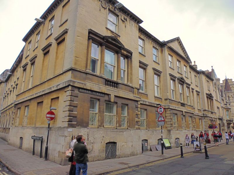
BALLIOL COLLEGE
1.
1485
Garden Quadrangle
Fisher Buildings
SP 5106 SW 8/138G 12.1.54.
II
2.
1769 by Henry Keene. South front (on Broad Street) refaced 1877 in Bath
ashlar. North front repaired in plastic, 1933. Reroofed with Buttermere
Westmorland slates in recent years.
Listing NGR: SP5130206441
External links are from the relevant listing authority and, where applicable, Wikidata. Wikidata IDs may be related buildings as well as this specific building. If you want to add or update a link, you will need to do so by editing the Wikidata entry.


Other nearby listed buildings
