Approximate Location Map
Large Map »
Latitude: 53.3236 / 53°19'24"N
Longitude: -0.9437 / 0°56'37"W
OS Eastings: 470455
OS Northings: 381258
OS Grid: SK704812
Mapcode National: GBR PZV0.H9
Mapcode Global: WHFG8.GQVG
Plus Code: 9C5X83F4+CG
Entry Name: 11 and 13, Bridgegate
Listing Date: 5 November 1976
Grade: II
Source: Historic England
Source ID: 1370356
English Heritage Legacy ID: 240854
ID on this website: 101370356
Location: Retford, Bassetlaw, Nottinghamshire, DN22
County: Nottinghamshire
District: Bassetlaw
Electoral Ward/Division: East Retford West
Parish: Non Civil Parish
Built-Up Area: Retford
Traditional County: Nottinghamshire
Lieutenancy Area (Ceremonial County): Nottinghamshire
Church of England Parish: Retford Team
Church of England Diocese: Southwell and Nottingham
Tagged with: Building
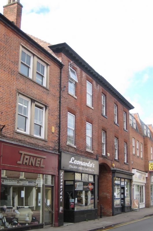
BRIDGEGATE
1.
5345
(South Side)
Nos 11 and 13
SK 7081 SW 1/53
II GV
2.
Early C19. 3 storeys in brick with wide wood eaves cornice. 5 windows, hung
sashes with glazing bars, brick voussoirs. Ground floor has central segmental-
headed carriage entry and modern and mid-late C19 shop fronts.
Nos 11 and 13 form a visual group with No. 16 (opposite).
Listing NGR: SK7045581258
External links are from the relevant listing authority and, where applicable, Wikidata. Wikidata IDs may be related buildings as well as this specific building. If you want to add or update a link, you will need to do so by editing the Wikidata entry.


Other nearby listed buildings
