Latitude: 53.4075 / 53°24'26"N
Longitude: -0.8949 / 0°53'41"W
OS Eastings: 473561
OS Northings: 390643
OS Grid: SK735906
Mapcode National: GBR QY61.17
Mapcode Global: WHFFX.7M33
Plus Code: 9C5XC444+X2
Entry Name: Gringley Vicarage and Boundary Wall
Listing Date: 23 November 1984
Grade: II
Source: Historic England
Source ID: 1370394
English Heritage Legacy ID: 241126
ID on this website: 101370394
Location: Gringley on the Hill, Bassetlaw, Nottinghamshire, DN10
County: Nottinghamshire
District: Bassetlaw
Civil Parish: Gringley on the Hill
Built-Up Area: Gringley on the Hill
Traditional County: Nottinghamshire
Lieutenancy Area (Ceremonial County): Nottinghamshire
Church of England Parish: Gringley-on-the-Hill
Church of England Diocese: Southwell and Nottingham
Tagged with: Building
SK 79 SW GRINGLEY ON THE HILL HIGH STREET
(south side)
5/44 Gringley Vicarage
and boundary wall
G.V. II
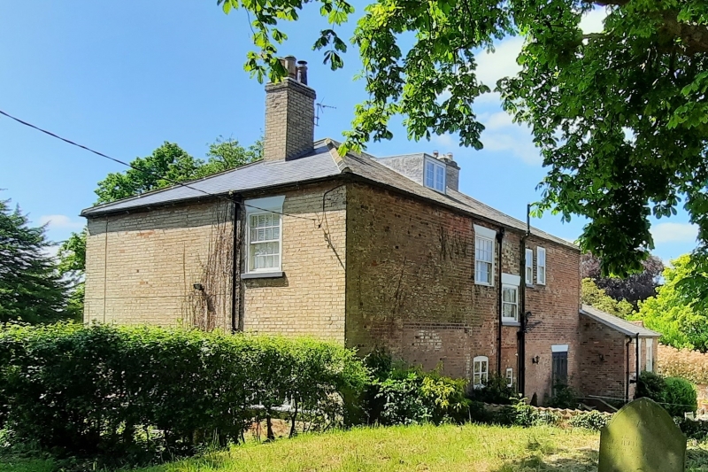
Vicarage, c.1837, built for Rev. H. N. Beaver. Gault brick with
red brick, stone and stucco details; hipped slate roof, 2 roof
stacks, 2 storeys, 3 bays square plan. Central moulded doorcase
with entablature and moulded hood, containing C19 half glazed
door with margin lights. Flanked by single square brick bays,
c.1915, with slate roofs and each with 5 glazing bar sashes.
Above, 3 glazing bar sashes with rendered lintels. Left side has
C19 brick extension with slate roof, one storey, one bay, and one
glazing bar sash on each floor. Right side has single C20 4 Light
casement, and above single glazing bar sash. Rear has irregular
C19 fenestration. Outside, terra-cotta coped boundary wall,
gault brick wth red brick patterning and cross shaped openings.
3 square piers with square stone caps; pair of square gatepiers
with recessed panels and pyramidal stone caps. Approx. 20m long
section to north of gateway similar but rendered.
Listing NGR: SK7356190643
External links are from the relevant listing authority and, where applicable, Wikidata. Wikidata IDs may be related buildings as well as this specific building. If you want to add or update a link, you will need to do so by editing the Wikidata entry.


Other nearby listed buildings