Latitude: 55.334 / 55°20'2"N
Longitude: -1.5396 / 1°32'22"W
OS Eastings: 429305
OS Northings: 604532
OS Grid: NU293045
Mapcode National: GBR K6PR.HQ
Mapcode Global: WHC21.B637
Plus Code: 9C7W8FM6+H5
Entry Name: Lighthouse and Attached Buildings
Listing Date: 31 December 1969
Grade: II*
Source: Historic England
Source ID: 1371130
English Heritage Legacy ID: 236802
Also known as: Coquet Island Lighthouse
ID on this website: 101371130
Location: Northumberland, NE65
County: Northumberland
Civil Parish: Hauxley
Lieutenancy Area (Ceremonial County): Northumberland
Church of England Parish: Amble
Church of England Diocese: Newcastle
Tagged with: Lighthouse
HAUXLEY COQUET ISLAND NU 20 SE 8/133 Lighthouse and attached buildings 31.12.69 GV II*
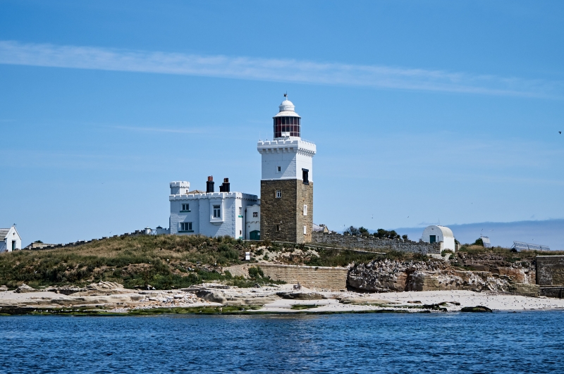
Benedictine monastic cell, C14 or C15; early C19 lighthouse-keeper's cottage built into chapel ruins, other parts incorporated in 1841 Trinity House lighthouse complex. Medieval parts squared stone of varying quality; cottage large squared stone; 1841 parts squared stone with raised tooled-and-margined quoins and dressings. Flat roofs not seen, except for cottage roof of slates with C20 waterproof covering.
Plan: The cell consisted of an east-west 2-storey domestic range with an attached chapel to the east, with north-west sacristy turret. Tower, perhaps originally detached, to south of west end of domestic range. In 1841 a new dwelling block was built incorporating the undercroft of the domestic range, with a lobby linking it to the tower; the upper part of the tower was rebuilt to carry the lighthouse lantern.
South elevation: Tower to left, with chamfered plinth. The lower 3 floors are medieval, with traces of old openings, and C19 windows; recessed top stage with corbelled-out embattled parapet and circular lantern with swept dome and weathervane. Right return shows blocked medieval loops to lower 2 floors; lobby on right has vertical-panelled door with Gothick sidelights, all within segmental-pointed arch, and paired 6-pane casements above. Set back to right of tower is 3-bay domestic range with boarded door under 4-centred arch, buttress-like projection for newel stair, and 2 enlarged basement loops; 1841 upper floor does not extend over full length, and has medieval walling with chamfered 1st-floor window to right. Far right single-storey 5-bay cottage which has central gabled porch with boarded door on each return, and hipped roof with stepped-and-banded ridge stack. Cottage right return incorporates east end of chapel with double-chamfered jambs and sill of large windows; at foot of wall is worn C14 cross slab.
North elevation: 1841 3-bay block to right, with central projection carried up as octagonal turret; embattled parapets on corbels. To left, beyond attached yard and outbuildings, is rear wall of cottage incorporating parts of north wall of chapel including projecting sacristy turret with upper floor on oversailing chamfered course, and squinch arches between returns and main wall behind.
West elevation: 1841 block on left, the right part set forward, with oriel window. Set back to right is lower lobby, with vertical-panelled double doors in segmental pointed arch under Trinity House arms in gable. To far right is tower, with C19 windows.
1841 parts have raised window surrounds with extended lintels and sills; glazing mostly renewed.
Interior: Medieval domestic range has undercroft with pointed tunnel vault, now divided into 3 chambers; 2 blocked doors in west end, and blocked newel stair in south. Interior of sacristy (turret appears to be solid at ground floor level) shows drawbar tunnel in door jamb, and drains and flue in wall thickness. Tower much altered in C19, although basement with pointed barrel vault may be medieval.
Historical Notes. Almost certainly the site of a Celtic monastery; St. Cuthbert met Abbess Elfleda of Whitby here in 684. In the medieval period the home of two noteworthy hermits, the Dane St. Henry of Coquet, and Martin who angered Robert fitz Roger of Warkworth by building his own windmill; later a cell of Tynemouth Priory - the Prior mentioned as owning 'Coket-Island Tower' in 1415. After the Dissolution used by coin counterfeiters, and garrisoned as a military outpost taken by the Scots in 1643.
Yard walls and single-storey outbuildings to north of 1841 block are not of special interest.
Article and plan by W.H. Knowles in 'Northumberland County History' V, 319-321 (1899).
Listing NGR: NU2930504532
External links are from the relevant listing authority and, where applicable, Wikidata. Wikidata IDs may be related buildings as well as this specific building. If you want to add or update a link, you will need to do so by editing the Wikidata entry.


Other nearby listed buildings