Latitude: 52.747 / 52°44'49"N
Longitude: -2.4863 / 2°29'10"W
OS Eastings: 367272
OS Northings: 316703
OS Grid: SJ672167
Mapcode National: GBR BW.02LP
Mapcode Global: WH9CW.S68Y
Plus Code: 9C4VPGW7+QF
Entry Name: Church of St Chad
Listing Date: 18 June 1959
Last Amended: 8 April 1983
Grade: II*
Source: Historic England
Source ID: 1374541
English Heritage Legacy ID: 362253
ID on this website: 101374541
Location: St Chad's Church, Kynnersley, Telford and Wrekin, Shropshire, TF6
County: Telford and Wrekin
Civil Parish: Kynnersley
Traditional County: Shropshire
Lieutenancy Area (Ceremonial County): Shropshire
Church of England Parish: Kynnersley St Chad
Church of England Diocese: Lichfield
Tagged with: Church building
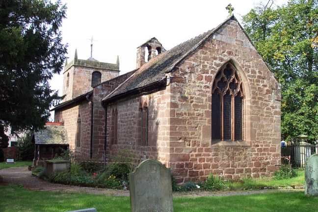
KYNNERSLEY Church of St Chad
1.
5362 (Formerly listed as Parish
Church)
SJ 61NE 23/400 18.6.59
II* GV
2.
Small sandstone built church. Medieval nave has C19 restored 2 and 3-light windows
with plate tracery and one straight headed window on north side. Gabled double
bellcote over east end of nave. South doorway with pointed chamfered arch.
Medieval chancel with early C14 windows the east window of 3-lights has reticulated
tracery, and 2-light lancet north and south windows. Late C19 timbers framed gabled
south porch.
West tower built 1722-3, of 2 stages with covered cornice beneath the parapet and
obelisk pinnacles at the corners. Round arched bell-openings, west window and
south doorway.
Interior: Double-chamfered chancel arch on short shafts supported on corbels. Nave
roof has moulded tiebeams but above that it seems to have been replaced. Chancel
roof has moulded collars, arched braces and queen struts.
Simple ogee-arched piscina in south wall of chancel.
Font has rough round bowl on Victorian stem. Victorian furnishings. In the
churchyard some early C19 and later railed tomb chests and to south of church some
C18 headstones and a table tomb.
Listing NGR: SJ6727216703
External links are from the relevant listing authority and, where applicable, Wikidata. Wikidata IDs may be related buildings as well as this specific building. If you want to add or update a link, you will need to do so by editing the Wikidata entry.


Other nearby listed buildings