Latitude: 53.0778 / 53°4'40"N
Longitude: -1.8094 / 1°48'33"W
OS Eastings: 412867
OS Northings: 353416
OS Grid: SK128534
Mapcode National: GBR 480.5C6
Mapcode Global: WHCDR.5WNV
Plus Code: 9C5W35HR+47
Entry Name: Lower Damgate Farmhouse and Attached Stable and Loft
Listing Date: 15 March 1985
Grade: II
Source: Historic England
Source ID: 1374577
English Heritage Legacy ID: 274469
ID on this website: 101374577
Location: Stanshope, Staffordshire Moorlands, Staffordshire, DE6
County: Staffordshire
District: Staffordshire Moorlands
Civil Parish: Ilam
Traditional County: Staffordshire
Lieutenancy Area (Ceremonial County): Staffordshire
Church of England Parish: Ilam
Church of England Diocese: Lichfield
Tagged with: Farmhouse
SK 15 SW ILAM C.P. ILAM MOOR LANE (East side)
8/111 Lower Damgate Farmhouse - and attached stable and loft.
- II
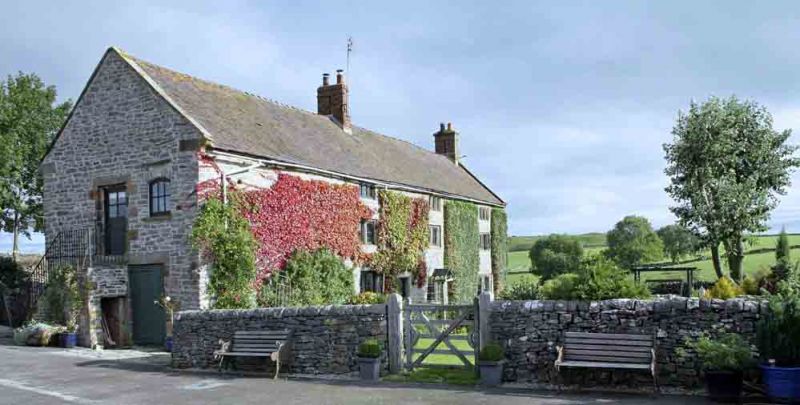
Farmhouse and attached stable and loft to West. Early to mid C18. Coursed limestone rubble with ashlar dressings; clay tile roof with coped verges on kneelers and ridge continuous over house and stable; brick integral end stack to East and central stack. T-shape; baffle entry plan. 3 storeys; 3 windows; chamfered mullioned, those to ground floor and first floor and first floor of 2 lights, those to second floor of 3 lights; ground floor window to left of centre has been replaced by a tall C19 casement; second floor window to left of centre has lost its mullions; central door opposite chimney stack. Attached Stable and loft to left; early to mid C19; blind to front; gable has ground floor board door to right and central first floor board door approached by stone tallet steps; first floor segmental headed window, now boarded, to right.
Listing NGR: SK1286753416
External links are from the relevant listing authority and, where applicable, Wikidata. Wikidata IDs may be related buildings as well as this specific building. If you want to add or update a link, you will need to do so by editing the Wikidata entry.


Other nearby listed buildings