Latitude: 53.8333 / 53°49'59"N
Longitude: -1.5924 / 1°35'32"W
OS Eastings: 426924
OS Northings: 437525
OS Grid: SE269375
Mapcode National: GBR B65.LN
Mapcode Global: WHC95.HXY6
Plus Code: 9C5WRCM5+83
Entry Name: The Coach House and Boundary Wall
Listing Date: 4 July 1996
Grade: II
Source: Historic England
Source ID: 1375328
English Heritage Legacy ID: 466223
ID on this website: 101375328
Location: West Park, Leeds, West Yorkshire, LS16
County: Leeds
Electoral Ward/Division: Weetwood
Parish: Non Civil Parish
Built-Up Area: Leeds
Traditional County: Yorkshire
Lieutenancy Area (Ceremonial County): West Yorkshire
Church of England Parish: Far Headingley St Chad
Church of England Diocese: Leeds
Tagged with: Building
LEEDS
SE23NE OTLEY ROAD, Weetwood 714-1/6/1216 (East side) 04/07/96 No.184 The Coach House and boundary wall
GV II
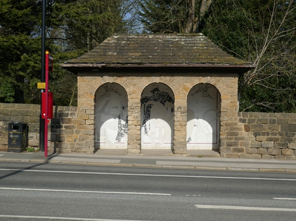
Coach-house and stables to Spenfield (qv), now offices of Yorkshire Water Estates, with boundary wall. 1875-1877, wall repositioned and reduced in length 1990s. Probably by George Corson. Rock-faced gritstone ashlar, ashlar details, blue slate hipped roof. 1- and 2-storey main range, single-storey range parallel to road with circular turret at S end. S front, to former yard: 3 coach-house openings now office windows, 4-pane sash, door and window in former wide opening, two 4-pane windows. First floor: 1:3:1 windows, the eaves raised over the central group. Shaped wooden gutter brackets, steeply-pitched roof, crested ridge tiles, tall chamfered ashlar ridge stack. INTERIOR: not inspected. SUBSIDIARY FEATURES: boundary wall parallel to road links to No.180, the Lodge (qv); a round-arched bus shelter has been built into it.
Listing NGR: SE2692437525
External links are from the relevant listing authority and, where applicable, Wikidata. Wikidata IDs may be related buildings as well as this specific building. If you want to add or update a link, you will need to do so by editing the Wikidata entry.


Other nearby listed buildings