Approximate Location Map
Large Map »
Latitude: 53.8554 / 53°51'19"N
Longitude: -1.6051 / 1°36'18"W
OS Eastings: 426072
OS Northings: 439982
OS Grid: SE260399
Mapcode National: GBR KR7V.9P
Mapcode Global: WHC95.9CX6
Plus Code: 9C5WV94V+5X
Entry Name: High Farm Public House Lounge and Food Bar
Listing Date: 26 September 1963
Last Amended: 11 September 1996
Grade: II
Source: Historic England
Source ID: 1375448
English Heritage Legacy ID: 466344
ID on this website: 101375448
Location: Holt Park, Leeds, West Yorkshire, LS16
County: Leeds
Electoral Ward/Division: Adel and Wharfedale
Parish: Non Civil Parish
Built-Up Area: Leeds
Traditional County: Yorkshire
Lieutenancy Area (Ceremonial County): West Yorkshire
Church of England Parish: Ireland Wood St Paul
Church of England Diocese: Leeds
Tagged with: Pub
LEEDS
SE23NE FARRAR LANE, Cookridge
714-1/6/633 (North side (off))
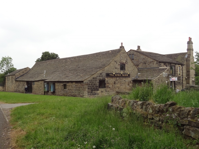
26/09/63 High Farm Public House, Lounge and
Food Bar
(Formerly Listed as:
FARRAR LANE, Cookridge
(North side (off))
Barn immediately north of High Farm
House)
(Formerly Listed as:
FARRAR LANE, Cookridge
(North side (off))
Stables and outbuildings adjoining
north-east of barn north of High
Farm House)
GV II
Farm buildings, now part of public house complex. C17 or
earlier timber-frame, clad in stone probably c1725, with C19
alterations and conversion c1976. Timber-frame clad in coursed
squared gritstone, stone slate roof. Approx 6 bays long, with
N aisle added when stone casing built. Quoins.
S side: barn doorway almost full height of wall, with rebuilt
jambs and segmental arch of shaped voussoirs. Flanking square
hay eyes with plain stone surrounds, now glazed. c1976 linking
bay to public house rear wing projects left. N front: low
stone walling supports N aisle roof; c1976 openings. Left
return: 2 barn slit vents; straight joint indicates N aisle is
secondary.
Outbuilding attached to east side of barn probably early C18,
altered c1976. Low 2 storeys, 2 bays. 2 entrances now windows,
2 small openings under eaves, one now a window and one
blocked.
INTERIOR: barn, the surviving timbers of a fully framed barn
include 3 full trusses with posts, tie beams, king posts with
angle struts, wall plates and braces to barn entrance; later
trusses extend barn to west.
The stables and outbuildings were listed on 9.1.75.
Listing NGR: SE2607239982
External links are from the relevant listing authority and, where applicable, Wikidata. Wikidata IDs may be related buildings as well as this specific building. If you want to add or update a link, you will need to do so by editing the Wikidata entry.


Other nearby listed buildings
