Approximate Location Map
Large Map »
Latitude: 51.1272 / 51°7'37"N
Longitude: 1.3246 / 1°19'28"E
OS Eastings: 632722
OS Northings: 141693
OS Grid: TR327416
Mapcode National: GBR X2Z.CP6
Mapcode Global: VHLHB.XX4R
Plus Code: 9F3348GF+VR
Entry Name: Dwarf Wall, Piers and Lamps to Steps Beneath Officers Barracks
Listing Date: 8 July 1998
Grade: II
Source: Historic England
Source ID: 1375602
English Heritage Legacy ID: 469566
ID on this website: 101375602
Location: Victoria Park Mews, Dover, Kent, CT16
County: Kent
District: Dover
Civil Parish: Dover
Built-Up Area: Dover
Traditional County: Kent
Lieutenancy Area (Ceremonial County): Kent
Tagged with: Wall
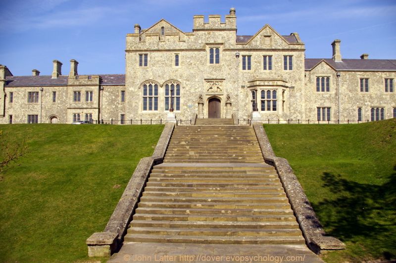
TR 3242 DOVER QUEEN ELIZABETH ROAD
(north side), Dover Castle
685/1/10006
Dwarf walls, piers and lamps to
Steps beneath Officers' barracks
GV II
Steps, walls, piers and lamps. c1858. Ashlar and cast-iron. Long flight of steps in 2 sections with dwarf walls each side terminating at the top in moulded plinths to tall iron lamp standards. Forms the approach to the officers' barracks (qv).
Listing NGR: TR3272241693
External links are from the relevant listing authority and, where applicable, Wikidata. Wikidata IDs may be related buildings as well as this specific building. If you want to add or update a link, you will need to do so by editing the Wikidata entry.


Other nearby listed buildings
