Latitude: 53.1862 / 53°11'10"N
Longitude: -2.8879 / 2°53'16"W
OS Eastings: 340767
OS Northings: 365828
OS Grid: SJ407658
Mapcode National: GBR 7B.370G
Mapcode Global: WH88F.M51P
Plus Code: 9C5V54P6+FV
Entry Name: Chester Weir and Salmon Leap
Listing Date: 23 July 1998
Grade: I
Source: Historic England
Source ID: 1375691
English Heritage Legacy ID: 469670
ID on this website: 101375691
Location: Chester, Cheshire West and Chester, Cheshire, CH1
County: Cheshire West and Chester
Electoral Ward/Division: Handbridge Park
Parish: Non Civil Parish
Built-Up Area: Chester
Traditional County: Cheshire
Lieutenancy Area (Ceremonial County): Cheshire
Church of England Parish: Chester St John the Baptist
Church of England Diocese: Chester
Tagged with: Weir
CHESTER CITY (EM)
SJ4065 RIVER DEE
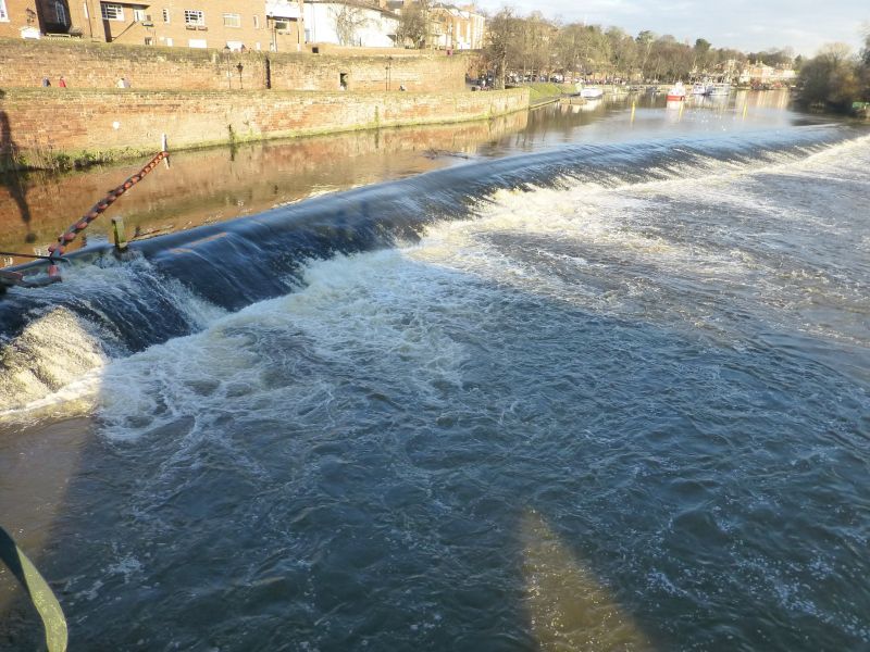
1932-1/8/66 Chester Weir and Salmon Leap
I
Weir and former causeway across River Dee. 1093. By Hugh Lupus
first Earl of Chester. For St Werburgh's Benedictine Abbey
(now Cathedral Church of Christ & the Blessed Virgin Mary,
Chester IM). Altered. Sandstone. Continuous weir with sloping
spillway of large rectangular stones. 120m long, at an acute
angle to the banks and at its north-west end parallel with the
bank for 33m, designed to provide the necessary head of water
for the medieval Mills of Dee, built and enlarged from 1093 to
provide 6 mill-wheels and trains of machinery by 1270; stone
salmon leap, altered; leat for later mill, altered, adjoining
the south bank. The mills on the north bank were demolished
1910, that on the south bank c1970.
HISTORICAL NOTE: the Mills of Dee for which it provided power
were amongst the largest and most valuable in England during
the C13, the annual rental being 270 pounds. The weir was
restored early C20 to serve the City Council's hydro-electric
power station, which operated 1913 to 1939, on the site of the
former mills.
(Cheshire SMR: Collens J: 3008/4/2; History of Cornmilling:
Bennet R & Elton J: Some Feudal Mills: Liverpool: 1904-).
Listing NGR: SJ4076765828
External links are from the relevant listing authority and, where applicable, Wikidata. Wikidata IDs may be related buildings as well as this specific building. If you want to add or update a link, you will need to do so by editing the Wikidata entry.


Other nearby listed buildings